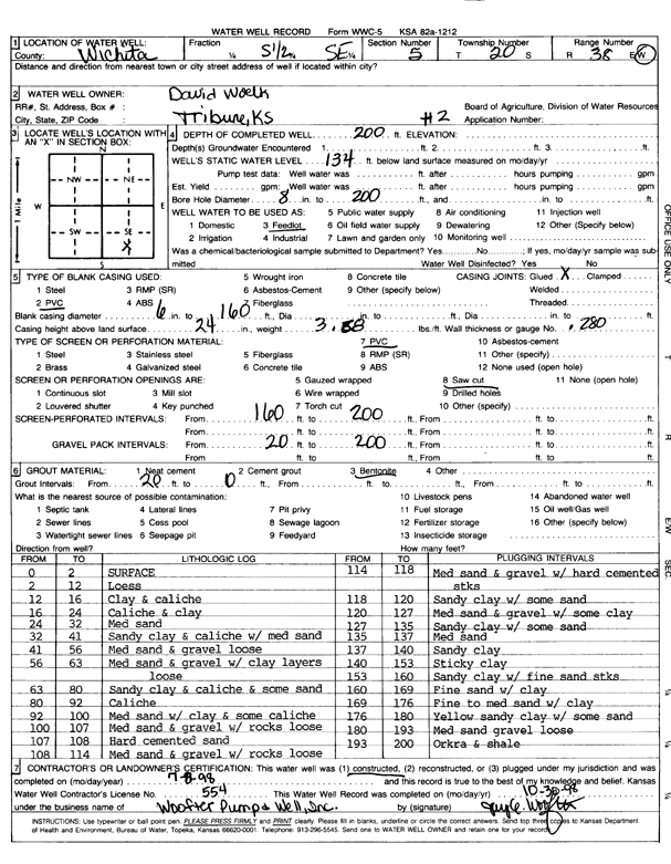
Lithologic Log
(Log data entered by KGS.) |
| |
From: 0 ft. to 2 ft. |
Surface |
| |
From: 2 ft. to 12 ft. |
Loess |
| |
From: 12 ft. to 16 ft. |
Clay and caliche |
| |
From: 16 ft. to 24 ft. |
Caliche and clay |
| |
From: 24 ft. to 32 ft. |
Medium sand |
| |
From: 32 ft. to 41 ft. |
Sandy clay and caliche with medium sand |
| |
From: 41 ft. to 56 ft. |
Medium sand and gravel, loose |
| |
From: 56 ft. to 63 ft. |
Medium sand and gravel with clay layers, loose |
| |
From: 63 ft. to 80 ft. |
Sandy clay and caliche and some sand |
| |
From: 80 ft. to 92 ft. |
Caliche |
| |
From: 92 ft. to 100 ft. |
Medium sand with clay and some caliche |
| |
From: 100 ft. to 107 ft. |
Medium sand and gravel with rocks, loose |
| |
From: 107 ft. to 108 ft. |
Hard cemented sand |
| |
From: 108 ft. to 114 ft. |
Medium sand and gravel with rocks, loose |
| |
From: 114 ft. to 118 ft. |
Medium sand and gravel with hard cemented streaks |
| |
From: 118 ft. to 120 ft. |
Sandy clay with some sand |
| |
From: 120 ft. to 127 ft. |
Medium sand and gravel with some clay |
| |
From: 127 ft. to 135 ft. |
Sandy clay with some sand |
| |
From: 135 ft. to 137 ft. |
Medium sand |
| |
From: 137 ft. to 140 ft. |
Sandy clay |
| |
From: 140 ft. to 153 ft. |
Sticky clay |
| |
From: 153 ft. to 160 ft. |
Sandy clay with fine sand streaks |
| |
From: 160 ft. to 169 ft. |
Fine sand with clay |
| |
From: 169 ft. to 176 ft. |
Fine to medium sand with clay |
| |
From: 176 ft. to 180 ft. |
Yellow sandy clay with some sand |
| |
From: 180 ft. to 193 ft. |
Medium sand and gravel, loose |
| |
From: 193 ft. to 200 ft. |
Ochre and shale |