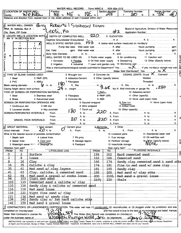
KGS Home Page Water Well Data base Specific Water Well Detail
Water Resources

Well T20S, R38W, Sec. 28, NE NE NE, Action: Constructed

Location Info
Owner: Seaboard Farms Co. Status: Constructed
Location: T20S, R38W, Sec. 28, NE NE NE County: Wichita
Directions:
Latitude: 38.291361 Longitude: -101.51278 Datum NAD 27
Latitude: 38.2913784 Longitude: -101.513224 Datum NAD 83
Longitude and latitude calculated by Survey from township-range-section-quarter calls. Only good to within the quarter call accuracy.
View well on interactive map
General Info
Well Depth: 220 ft. Elevation: ft.
Static Water Level: 153 ft. Est. Yield: gpm.
Comp. Date: 02-Jul-1998 Well Use: Feedlot
DWR Applic. #: Other ID: Well 2
Driller Info
Driller: Woofter Pump & Well, Inc. License #: 554
Scanned Form
View form(s) on screen Download scan(s)
The download files contain one or more TIFF images compressed into a ZIP archive. Your browser may be already set up to decompress these files. The TIFFs are 300 dpi archival-quality scans of the WWC5 forms and can be viewed by software like Adobe PhotoShop.
Chemical Sample Submitted?:
Water Well disinfected?:
Casing Info
Casing Type:
Casing Joints:
Diam: in. to ft
Casing height above land surface: in
Casing Weight: lbs/ft
Wall thickness or gauge no.:
Screen and Perforation Info
Screen Type: Screen Openings:
Screen-perforated intervals From: ft to ft
Gravel pack intervals From: ft to ft
Grout Info
Grout used: From: to ft
Source of Possible Contamination
Source:
Direction from well: Distance: ft
Lithologic Log
(Log data entered by KGS.)
From: 0 ft. to 2 ft. Surface
From: 2 ft. to 8 ft. Loess
From: 8 ft. to 16 ft. Clay
From: 16 ft. to 35 ft. Caliche and clay
From: 35 ft. to 41 ft. Medium sand with clay layers
From: 41 ft. to 62 ft. Clay, caliche, and cemented sand
From: 62 ft. to 94 ft. Medium sand and gravel with rocks, loose
From: 94 ft. to 103 ft. Tight medium sand
From: 103 ft. to 110 ft. Cemented sand and caliche with clay
From: 110 ft. to 116 ft. Sandy clay and caliche with cemented sand
From: 116 ft. to 118 ft. Medium sand, loose
From: 118 ft. to 121 ft. Tight fine sand with clay
From: 121 ft. to 134 ft. Medium sand with sandy clay
From: 134 ft. to 142 ft. Sandy clay with few hard caliche streaks
From: 142 ft. to 159 ft. Medium sand and gravel, loose
From: 159 ft. to 162 ft. Hard cemented sand
From: 162 ft. to 166 ft. Cemented sand
From: 166 ft. to 174 ft. Sandy clay, cemented sand, and sand streaks
From: 174 ft. to 181 ft. Fine to medium sand with some clay
From: 181 ft. to 195 ft. Sandy clay
From: 195 ft. to 200 ft. Medium sand with clay streaks
From: 200 ft. to 216.5 ft. Medium sand and gravel, loose
From: 216.5 ft. to 220 ft. Shale

Kansas Geological Survey
Comments to webadmin@kgs.ku.edu
URL=http://www.kgs.ku.edu/Magellan/WaterWell/index.html
Display Programs Updated July 2, 2014
Data added continuously.