|
|
|
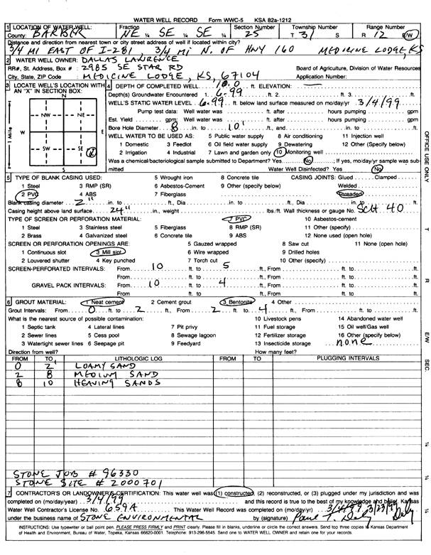
Specific Water Well Detail |
|
|
| Location Info | |||
| Owner: Lawrence, Dallas | Status: Constructed | ||
| Location: T31S, R12W, Sec. 25, NE SE SE | County: Barber | ||
| Directions: from Medicine Lodge, 0.75 mi E of Hwy 281 and 0.75 mi N of Hwy 160 (tag 2000701) | |||
| Latitude: 37.3147792 | Longitude: -98.5692149 | Datum NAD 27 | |
| Latitude: 37.3148014 | Longitude: -98.5695757 | Datum NAD 83 | |
| Longitude and latitude calculated by Survey from township-range-section-quarter calls. Only good to within the quarter call accuracy. | |||
| View well on interactive map | |||
| General Info | ||
| Well Depth: 10 ft. | Elevation: ft. | |
| Static Water Level: 6.99 ft. | Est. Yield: gpm. | |
| Comp. Date: 04-Mar-1999 | Well Use: Monitoring well/observation/piezometer | |
| DWR Applic. #: | Other ID: | |
| Driller Info | ||
| Driller: Stone Environmental | License #: 659 | |
| Scanned Form | View scan |
|
Chemical Sample Submitted?:
Water Well disinfected?: | ||
| Casing Info | ||
| Casing Type:
Casing Joints: |
Diam: in. to ft | |
| Casing height above land surface: in
Casing Weight: lbs/ft Wall thickness or gauge no.: | ||
| Screen and Perforation Info | ||
| Screen Type: | Screen Openings: | |
| Screen-perforated intervals | From: ft to ft | |
| Gravel pack intervals | From: ft to ft | |
| Grout Info | ||
| Grout used: | From: to ft | |
| Source of Possible Contamination | ||
| Source: | ||
| Direction from well: | Distance: ft | |
| Lithologic Log
(Log data entered by KGS.) | ||
| From: 0 ft. to 2 ft. | loamy sand | |
| From: 2 ft. to 8 ft. | medium sand | |
| From: 8 ft. to 10 ft. | heaving sand | |