|
|
|
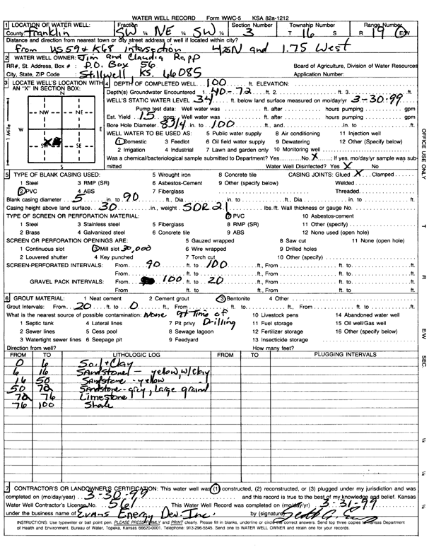
Specific Water Well Detail |
|
|
| Location Info | |||
| Owner: Rapp, Jim and Claudia | Status: Constructed | ||
| Location: T16S, R19E, Sec. 3, SW NE SW | County: Franklin | ||
| Directions: from US 59 and K-68: 4.25 mi N, 1.75 mi W | |||
| Latitude: 38.6855716 | Longitude: -95.2985098 | Datum NAD 27 | |
| Latitude: 38.6855806 | Longitude: -95.2987622 | Datum NAD 83 | |
| Longitude and latitude calculated by Survey from township-range-section-quarter calls. Only good to within the quarter call accuracy. | |||
| View well on interactive map | |||
| General Info | ||
| Well Depth: 100 ft. | Elevation: ft. | |
| Static Water Level: 34 ft. | Est. Yield: gpm. | |
| Comp. Date: 30-Mar-1999 | Well Use: Domestic | |
| DWR Applic. #: | Other ID: | |
| Driller Info | ||
| Driller: Evans Energy Development, Inc. | License #: 561 | |
| Scanned Form | View scan |
|
Chemical Sample Submitted?:
Water Well disinfected?: | ||
| Casing Info | ||
| Casing Type:
Casing Joints: |
Diam: in. to ft | |
| Casing height above land surface: in
Casing Weight: lbs/ft Wall thickness or gauge no.: | ||
| Screen and Perforation Info | ||
| Screen Type: | Screen Openings: | |
| Screen-perforated intervals | From: ft to ft | |
| Gravel pack intervals | From: ft to ft | |
| Grout Info | ||
| Grout used: | From: to ft | |
| Source of Possible Contamination | ||
| Source: | ||
| Direction from well: | Distance: ft | |
| Lithologic Log
(Log data entered by KGS.) | ||
| From: 0 ft. to 6 ft. | Soil and clay | |
| From: 6 ft. to 16 ft. | Sandstone, yellow with clay | |
| From: 16 ft. to 50 ft. | Sandstone, yellow | |
| From: 50 ft. to 72 ft. | Large-grained sandstone, gray | |
| From: 72 ft. to 76 ft. | Limestone | |
| From: 76 ft. to 100 ft. | Shale | |