|
|
|
Specific Water Well Detail |
|
|
| Location Info | |||
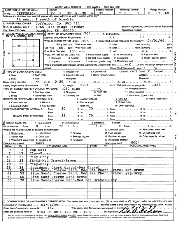
| Owner: Jefferson Co. RWD 11 | Status: Constructed | ||
| Location: T9S, R17E, Sec. 35, SW SW SW | County: Jefferson | ||
| Directions: from Ozawkie: 1.5 mi W, 1 mi S | |||
| Latitude: 39.2169955 | Longitude: -95.4956481 | Datum NAD 27 | |
| Latitude: 39.216994 | Longitude: -95.4959014 | Datum NAD 83 | |
| Longitude and latitude calculated by Survey from township-range-section-quarter calls. Only good to within the quarter call accuracy. | |||
| View well on interactive map | |||
| General Info | ||
| Well Depth: 70 ft. | Elevation: ft. | |
| Static Water Level: 35 ft. | Est. Yield: 85 gpm. | |
| Comp. Date: 01-Apr-1999 | Well Use: Public Water Supply | |
| DWR Applic. #: | Other ID: | |
| Driller Info | ||
| Driller: Strader Drilling Co., Inc. | License #: 182 | |
| Scanned Form | View scan |
|
Chemical Sample Submitted?:
Water Well disinfected?: | ||
| Casing Info | ||
| Casing Type:
Casing Joints: |
Diam: in. to ft | |
| Casing height above land surface: in
Casing Weight: lbs/ft Wall thickness or gauge no.: | ||
| Screen and Perforation Info | ||
| Screen Type: | Screen Openings: | |
| Screen-perforated intervals | From: ft to ft | |
| Gravel pack intervals | From: ft to ft | |
| Grout Info | ||
| Grout used: | From: to ft | |
| Source of Possible Contamination | ||
| Source: | ||
| Direction from well: | Distance: ft | |
| Lithologic Log
(Log data entered by KGS.) | ||
| From: 0 ft. to 2 ft. | top soil | |
| From: 2 ft. to 17 ft. | clay, brown | |
| From: 17 ft. to 21 ft. | clay, gray | |
| From: 21 ft. to 23 ft. | fine sand, coarse sand, medium gravel, brown | |
| From: 23 ft. to 35 ft. | clay, gray | |
| From: 35 ft. to 38 ft. | boulders, chert gravel, pea gravel | |
| From: 38 ft. to 49 ft. | fine sand, coarse sand, medium pea chert gravel, brown | |
| From: 49 ft. to 53 ft. | fine sand, coarse sand, medium pea chert gravel, gray | |
| From: 53 ft. to 66 ft. | fine sand, coarse sand, brown | |
| From: 66 ft. to 70 ft. | fine sand, coarse sand, medium pea gravel, gray | |