|
|
|
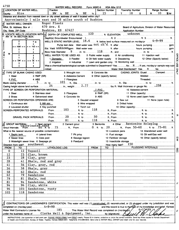
Specific Water Well Detail |
|
|
| Location Info | |||
| Owner: Plautz, Roger | Status: Constructed | ||
| Location: T18S, R10W, Sec. 25, NW NE NE | County: Rice | ||
| Directions: from Bushton: 1 mi E, 3.5 mi S | |||
| Latitude: 38.4627655 | Longitude: -98.3726396 | Datum NAD 27 | |
| Latitude: 38.4627762 | Longitude: -98.372984 | Datum NAD 83 | |
| Longitude and latitude calculated by Survey from township-range-section-quarter calls. Only good to within the quarter call accuracy. | |||
| View well on interactive map | |||
| General Info | ||
| Well Depth: 120 ft. | Elevation: ft. | |
| Static Water Level: 18.6 ft. | Est. Yield: gpm. | |
| Comp. Date: 09-Apr-1999 | Well Use: Domestic | |
| DWR Applic. #: | Other ID: | |
| Driller Info | ||
| Driller: Clarke Well and Equipment, Inc. | License #: 185 | |
| Scanned Form | View scan |
|
Chemical Sample Submitted?:
Water Well disinfected?: | ||
| Casing Info | ||
| Casing Type:
Casing Joints: |
Diam: in. to ft | |
| Casing height above land surface: in
Casing Weight: lbs/ft Wall thickness or gauge no.: | ||
| Screen and Perforation Info | ||
| Screen Type: | Screen Openings: | |
| Screen-perforated intervals | From: ft to ft | |
| Gravel pack intervals | From: ft to ft | |
| Grout Info | ||
| Grout used: | From: to ft | |
| Source of Possible Contamination | ||
| Source: | ||
| Direction from well: | Distance: ft | |
| Lithologic Log
(Log data entered by KGS.) | ||
| From: 0 ft. to 12 ft. | top soil | |
| From: 12 ft. to 23 ft. | clay, brown | |
| From: 23 ft. to 28 ft. | clay, gray | |
| From: 28 ft. to 41 ft. | shale, red and gray | |
| From: 41 ft. to 56 ft. | clay, gray, red | |
| From: 56 ft. to 58 ft. | shale, gray | |
| From: 58 ft. to 62 ft. | shale, red | |
| From: 62 ft. to 79 ft. | sandstone | |
| From: 79 ft. to 81 ft. | shale, red | |
| From: 81 ft. to 94 ft. | sandstone, white | |
| From: 94 ft. to 96 ft. | clay, white | |
| From: 96 ft. to 103 ft. | sandstone, rusty | |
| From: 103 ft. to 118 ft. | sandstone | |