|
|
|
Specific Water Well Detail |
|
|
| Location Info | |||
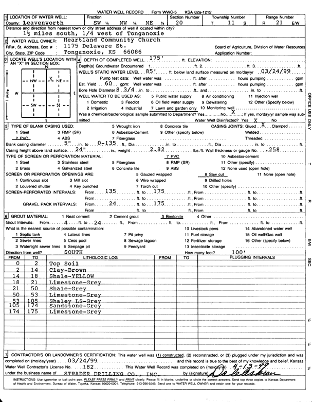
| Owner: Heartland Community Church | Status: Constructed | ||
| Location: T11S, R21E, Sec. 20, SW NW NE | County: Leavenworth | ||
| Directions: from Tonganoxie: 1.5 mi S, .25 mi W | |||
| Latitude: 39.0848083 | Longitude: -95.1014569 | Datum NAD 27 | |
| Latitude: 39.0848102 | Longitude: -95.1017038 | Datum NAD 83 | |
| Longitude and latitude calculated by Survey from township-range-section-quarter calls. Only good to within the quarter call accuracy. | |||
| View well on interactive map | |||
| General Info | ||
| Well Depth: 175 ft. | Elevation: ft. | |
| Static Water Level: 85 ft. | Est. Yield: 60 gpm. | |
| Comp. Date: 24-Mar-1999 | Well Use: Domestic, Lawn and Garden | |
| DWR Applic. #: | Other ID: | |
| Links | |
| No Wizard information available. | |
| View info from WIMAS Water Right Data base... | |
| Driller Info | ||
| Driller: Strader Drilling Co., Inc. | License #: 182 | |
| Scanned Form | View scan |
|
Chemical Sample Submitted?:
Water Well disinfected?: | ||
| Casing Info | ||
| Casing Type:
Casing Joints: |
Diam: in. to ft | |
| Casing height above land surface: in
Casing Weight: lbs/ft Wall thickness or gauge no.: | ||
| Screen and Perforation Info | ||
| Screen Type: | Screen Openings: | |
| Screen-perforated intervals | From: ft to ft | |
| Gravel pack intervals | From: ft to ft | |
| Grout Info | ||
| Grout used: | From: to ft | |
| Source of Possible Contamination | ||
| Source: | ||
| Direction from well: | Distance: ft | |
| Lithologic Log
(Log data entered by KGS.) | ||
| From: 0 ft. to 2 ft. | top soil | |
| From: 2 ft. to 14 ft. | clay, brown | |
| From: 14 ft. to 18 ft. | shale, yellow | |
| From: 18 ft. to 21 ft. | limestone, gray | |
| From: 21 ft. to 50 ft. | shale, gray | |
| From: 50 ft. to 105 ft. | shaley limestone, gray | |
| From: 105 ft. to 174 ft. | sandstone, gray | |
| From: 174 ft. to 175 ft. | limestone, gray | |