|
|
|
Specific Water Well Detail |
|
|
| Location Info | |||
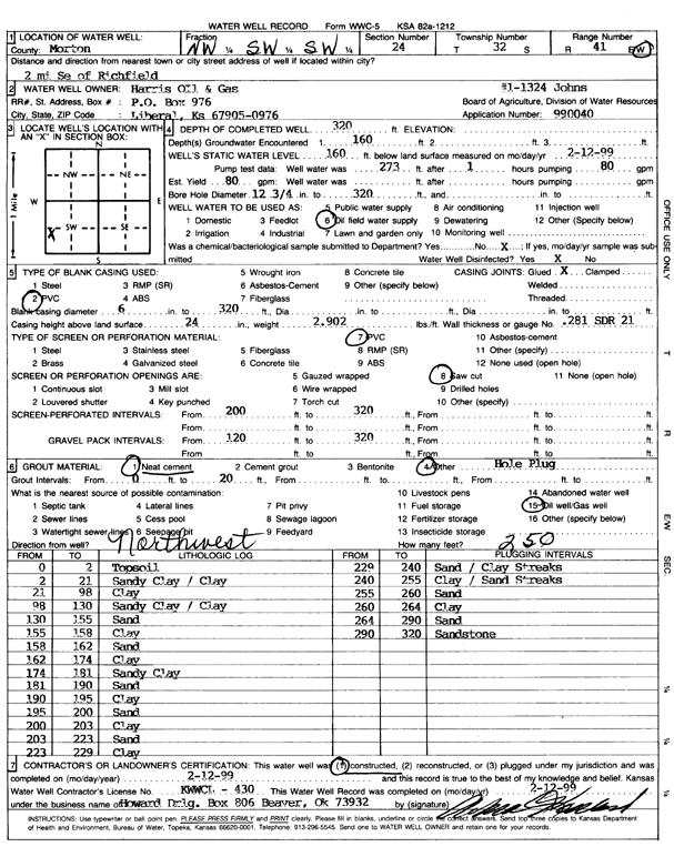
| Owner: Harris Oil and Gas | Status: Constructed | ||
| Location: T32S, R41W, Sec. 24, NW SW SW | County: Morton | ||
| Directions: from Richfield, 2 mi SE | |||
| Latitude: 37.2460231 | Longitude: -101.7355594 | Datum NAD 27 | |
| Latitude: 37.2460469 | Longitude: -101.736002 | Datum NAD 83 | |
| Longitude and latitude calculated by Survey from township-range-section-quarter calls. Only good to within the quarter call accuracy. | |||
| View well on interactive map | |||
| General Info | ||
| Well Depth: 320 ft. | Elevation: ft. | |
| Static Water Level: 160 ft. | Est. Yield: 80 gpm. | |
| Comp. Date: 12-Feb-1999 | Well Use: Oil Field Water Supply | |
| DWR Applic. #: 990040 | Other ID: Johns 1-1324 | |
| Links | |
| No Wizard information available. | |
| View info from WIMAS Water Right Data base... | |
| Driller Info | ||
| Driller: Howard Drilling Company AG, LLC | License #: 430 | |
| Scanned Form | View scan |
|
Chemical Sample Submitted?:
Water Well disinfected?: | ||
| Casing Info | ||
| Casing Type:
Casing Joints: |
Diam: in. to ft | |
| Casing height above land surface: in
Casing Weight: lbs/ft Wall thickness or gauge no.: | ||
| Screen and Perforation Info | ||
| Screen Type: | Screen Openings: | |
| Screen-perforated intervals | From: ft to ft | |
| Gravel pack intervals | From: ft to ft | |
| Grout Info | ||
| Grout used: | From: to ft | |
| Source of Possible Contamination | ||
| Source: | ||
| Direction from well: | Distance: ft | |
| Lithologic Log
(Log data entered by KGS.) | ||
| From: 0 ft. to 2 ft. | topsoil | |
| From: 2 ft. to 21 ft. | sandy clay / clay | |
| From: 21 ft. to 98 ft. | clay | |
| From: 98 ft. to 130 ft. | sandy clay / clay | |
| From: 130 ft. to 155 ft. | sand | |
| From: 155 ft. to 158 ft. | clay | |
| From: 158 ft. to 162 ft. | sand | |
| From: 162 ft. to 174 ft. | clay | |
| From: 174 ft. to 181 ft. | sandy clay | |
| From: 181 ft. to 190 ft. | sand | |
| From: 190 ft. to 195 ft. | clay | |
| From: 195 ft. to 200 ft. | sand | |
| From: 200 ft. to 203 ft. | clay | |
| From: 203 ft. to 223 ft. | sand | |
| From: 223 ft. to 229 ft. | clay | |
| From: 229 ft. to 240 ft. | sand / clay streaks | |
| From: 240 ft. to 255 ft. | clay / sand streaks | |
| From: 255 ft. to 260 ft. | sand | |
| From: 260 ft. to 264 ft. | clay | |
| From: 264 ft. to 290 ft. | sand | |
| From: 290 ft. to 320 ft. | sandstone | |