|
|
|
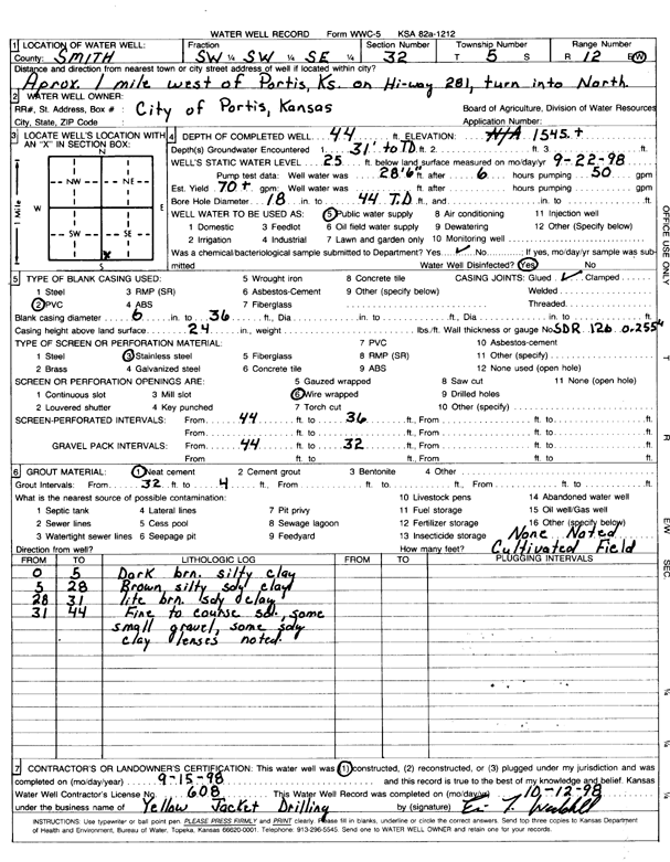
Specific Water Well Detail |
|
|
| Location Info | |||
| Owner: City of Portis | Status: Constructed | ||
| Location: T5S, R12W, Sec. 32, SW SW SE | County: Smith | ||
| Directions: from Portis, 1 mi W on Hwy 281, turn into north | |||
| Latitude: 39.5685318 | Longitude: -98.6997158 | Datum NAD 27 | |
| Latitude: 39.5685427 | Longitude: -98.7000658 | Datum NAD 83 | |
| Longitude and latitude calculated by Survey from township-range-section-quarter calls. Only good to within the quarter call accuracy. | |||
| View well on interactive map | |||
| General Info | ||
| Well Depth: 44 ft. | Elevation: 1545 ft. | |
| Static Water Level: 25 ft. | Est. Yield: 70 gpm. | |
| Comp. Date: 15-Sep-1998 | Well Use: Public Water Supply | |
| DWR Applic. #: | Other ID: | |
| Links | |
| No Wizard information available. | |
| View info from WIMAS Water Right Data base... | |
| Driller Info | ||
| Driller: Yellow Jacket Drilling | License #: 608 | |
| Scanned Form | View scan |
|
Chemical Sample Submitted?:
Water Well disinfected?: | ||
| Casing Info | ||
| Casing Type:
Casing Joints: |
Diam: in. to ft | |
| Casing height above land surface: in
Casing Weight: lbs/ft Wall thickness or gauge no.: | ||
| Screen and Perforation Info | ||
| Screen Type: | Screen Openings: | |
| Screen-perforated intervals | From: ft to ft | |
| Gravel pack intervals | From: ft to ft | |
| Grout Info | ||
| Grout used: | From: to ft | |
| Source of Possible Contamination | ||
| Source: | ||
| Direction from well: | Distance: ft | |
| Lithologic Log
(Log data entered by KGS.) | ||
| From: 0 ft. to 5 ft. | dark brown silty clay | |
| From: 5 ft. to 28 ft. | brown silty sandy clay | |
| From: 28 ft. to 31 ft. | light brown sandy clay | |
| From: 31 ft. to 44 ft. | fine to coarse sand, some small gravel, some sandy clay lenses | |