|
|
|
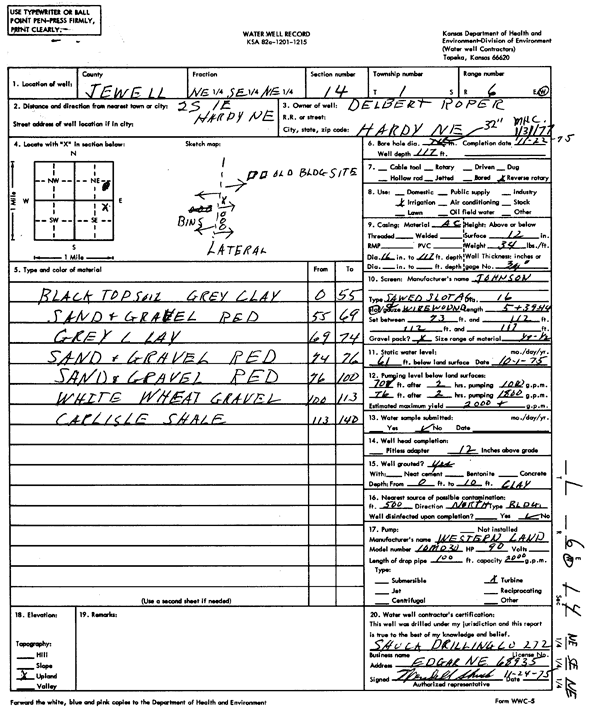
Specific Water Well Detail |
|
|
| Location Info | |||
| Owner: Roper, Delbert | Status: Constructed | ||
| Location: T1S, R6W, Sec. 14, NE SE NE | County: Jewell | ||
| Directions: from Hardy, NE, 2 mi S and 1 mi E | |||
| Latitude: 39.9675826 | Longitude: -97.951761 | Datum NAD 27 | |
| Latitude: 39.9675955 | Longitude: -97.9520822 | Datum NAD 83 | |
| Longitude and latitude calculated by Survey from township-range-section-quarter calls. Only good to within the quarter call accuracy. | |||
| View well on interactive map | |||
| General Info | ||
| Well Depth: 117 ft. | Elevation: ft. | |
| Static Water Level: 61 ft. | Est. Yield: 2000 gpm. | |
| Comp. Date: 22-Nov-1975 | Well Use: Irrigation | |
| DWR Applic. #: | Other ID: | |
| Links | |
| No Wizard information available. | |
| View info from WIMAS Water Right Data base... | |
| Driller Info | ||
| Driller: Dale Shuck Drilling Co. | License #: 272 | |
| Scanned Form | View scan |
|
Chemical Sample Submitted?: No
Water Well disinfected?: | ||
| Ground water encountered: 0 ft. , 0 ft. , 0 ft. | ||
| Pump test data: Well water was 0 ft after 0 hours pumping 0 gpm | ||
| Casing Info | ||
| Casing Type:
Casing Joints: |
Diam: 0 in. to 0 ft
Diam: 0 in. to 0 ft Diam: 0 in. to 0 ft | |
| Casing height above land surface: in
Casing Weight: lbs/ft Wall thickness or gauge no.: | ||
| Screen and Perforation Info | ||
| Screen Type: | Screen Openings: | |
| Screen-perforated intervals | From: 73 ft to 112 ft
From: 112 ft to 117 ft From: 0 ft to 0 ft | |
| Gravel pack intervals | From: ft to ft | |
| Grout Info | ||
| Grout used: | From: 0 to 0 ft
From: 0 to 0 ft From: 0 to 0 ft | |
| Source of Possible Contamination | ||
| Source: | ||
| Direction from well: | Distance: 0 ft | |
| Lithologic Log
(Log data entered by KGS.) | ||
| From: 0 ft. to 55 ft. | black top soil, gray clay | |
| From: 55 ft. to 69 ft. | sand and gravel, red | |
| From: 69 ft. to 74 ft. | gray clay | |
| From: 74 ft. to 76 ft. | sand and gravel, red | |
| From: 76 ft. to 100 ft. | sand and gravel, red | |
| From: 100 ft. to 113 ft. | white wheat gravel | |
| From: 113 ft. to 140 ft. | Carlisle shale | |