|
|
|
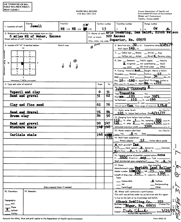
Specific Water Well Detail |
|
|
| Location Info | |||
| Owner: Doehring, Arlo; Baird, Sam; Nelson, Ritch | Status: Constructed | ||
| Location: T1S, R6W, Sec. 15, NE NE SW | County: Jewell | ||
| Directions: from Webber, 6 miles NE | |||
| Latitude: 39.9636942 | Longitude: -97.9801703 | Datum NAD 27 | |
| Latitude: 39.9637074 | Longitude: -97.9804917 | Datum NAD 83 | |
| Longitude and latitude calculated by Survey from township-range-section-quarter calls. Only good to within the quarter call accuracy. | |||
| View well on interactive map | |||
| General Info | ||
| Well Depth: 149 ft. | Elevation: ft. | |
| Static Water Level: 103 ft. | Est. Yield: 3500 gpm. | |
| Comp. Date: 24-Mar-1978 | Well Use: Irrigation | |
| DWR Applic. #: | Other ID: | |
| Links | |
| No Wizard information available. | |
| View info from WIMAS Water Right Data base... | |
| Driller Info | ||
| Driller: Dale Shuck Drilling Co. | License #: 272 | |
| Scanned Form | View scan |
|
Chemical Sample Submitted?: No
Water Well disinfected?: | ||
| Ground water encountered: 0 ft. , 0 ft. , 0 ft. | ||
| Pump test data: Well water was 0 ft after 0 hours pumping 0 gpm | ||
| Casing Info | ||
| Casing Type:
Casing Joints: |
Diam: 0 in. to 0 ft
Diam: 0 in. to 0 ft Diam: 0 in. to 0 ft | |
| Casing height above land surface: in
Casing Weight: lbs/ft Wall thickness or gauge no.: | ||
| Screen and Perforation Info | ||
| Screen Type: | Screen Openings: | |
| Screen-perforated intervals | From: 110 ft to 149 ft
From: 0 ft to 0 ft From: 0 ft to 0 ft | |
| Gravel pack intervals | From: ft to ft | |
| Grout Info | ||
| Grout used: | From: 0 to 0 ft
From: 0 to 0 ft From: 0 to 0 ft | |
| Source of Possible Contamination | ||
| Source: | ||
| Direction from well: | Distance: 0 ft | |
| Lithologic Log
(Log data entered by KGS.) | ||
| From: 0 ft. to 51 ft. | top soil and clay | |
| From: 51 ft. to 62 ft. | sand and gravel | |
| From: 62 ft. to 76 ft. | clay and fine sand | |
| From: 76 ft. to 84 ft. | sand and gravel | |
| From: 84 ft. to 90 ft. | brown clay | |
| From: 90 ft. to 147 ft. | sand and gravel | |
| From: 147 ft. to 148 ft. | Niobrara shale | |
| From: 148 ft. to 155 ft. | Carlisle shale | |