|
|
|
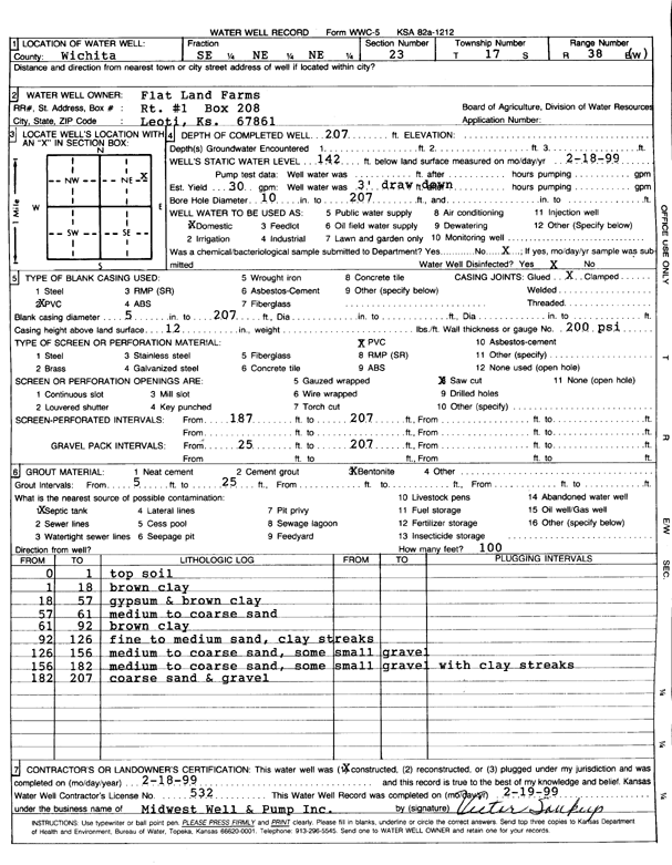
Specific Water Well Detail |
|
|
| Location Info | |||
| Owner: Flat Land Farms | Status: Constructed | ||
| Location: T17S, R38W, Sec. 23, SE NE NE | County: Wichita | ||
| Directions: | |||
| Latitude: 38.5656476 | Longitude: -101.4771773 | Datum NAD 27 | |
| Latitude: 38.5656634 | Longitude: -101.4776191 | Datum NAD 83 | |
| Longitude and latitude calculated by Survey from township-range-section-quarter calls. Only good to within the quarter call accuracy. | |||
| View well on interactive map | |||
| General Info | ||
| Well Depth: 207 ft. | Elevation: ft. | |
| Static Water Level: 142 ft. | Est. Yield: 30 gpm. | |
| Comp. Date: 18-Feb-1999 | Well Use: Domestic | |
| DWR Applic. #: | Other ID: | |
| Driller Info | ||
| Driller: Midwest Well & Pump, Inc. | License #: 532 | |
| Scanned Form | View scan |
|
Chemical Sample Submitted?:
Water Well disinfected?: | ||
| Casing Info | ||
| Casing Type:
Casing Joints: |
Diam: in. to ft | |
| Casing height above land surface: in
Casing Weight: lbs/ft Wall thickness or gauge no.: | ||
| Screen and Perforation Info | ||
| Screen Type: | Screen Openings: | |
| Screen-perforated intervals | From: ft to ft | |
| Gravel pack intervals | From: ft to ft | |
| Grout Info | ||
| Grout used: | From: to ft | |
| Source of Possible Contamination | ||
| Source: | ||
| Direction from well: | Distance: ft | |
| Lithologic Log
(Log data entered by KGS.) | ||
| From: 0 ft. to 1 ft. | Top soil | |
| From: 1 ft. to 18 ft. | Brown clay | |
| From: 18 ft. to 57 ft. | Gypsum and brown clay | |
| From: 57 ft. to 61 ft. | Medium to coarse sand | |
| From: 61 ft. to 92 ft. | Brown clay | |
| From: 92 ft. to 126 ft. | Fine to medium sand, clay streaks | |
| From: 126 ft. to 156 ft. | Medium to coarse sand, some small gravel | |
| From: 156 ft. to 182 ft. | Medium to coarse sand, some small gravel with clay streaks | |
| From: 182 ft. to 207 ft. | Coarse sand and gravel | |