|
|
|
Specific Water Well Detail |
|
|
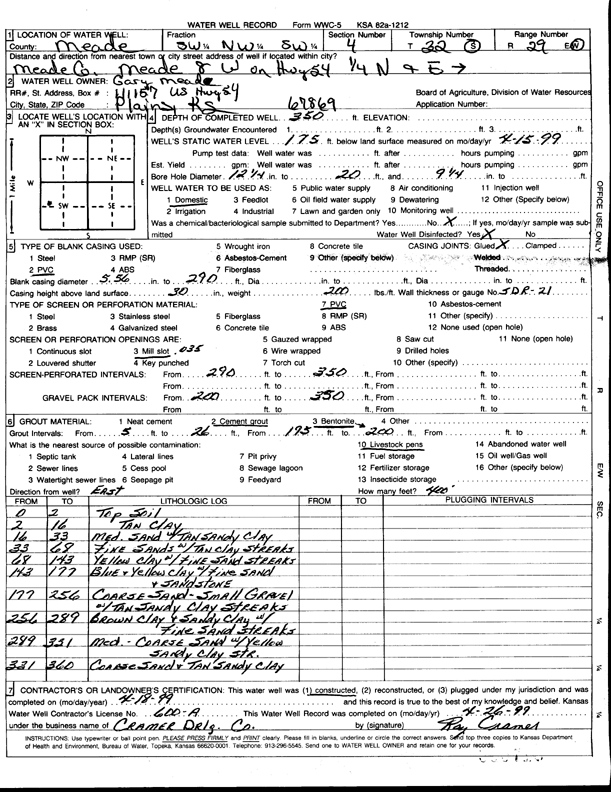
| Location Info | |||
| Owner: Meade, Gary | Status: Constructed | ||
| Location: T32S, R29W, Sec. 4, SW NW SW | County: Meade | ||
| Directions: from Meade: 8 mi W on Hwy 54, .25 mi N, E into site | |||
| Latitude: 37.2903851 | Longitude: -100.4878951 | Datum NAD 27 | |
| Latitude: 37.290408 | Longitude: -100.4883229 | Datum NAD 83 | |
| Longitude and latitude calculated by Survey from township-range-section-quarter calls. Only good to within the quarter call accuracy. | |||
| View well on interactive map | |||
| General Info | ||
| Well Depth: 350 ft. | Elevation: ft. | |
| Static Water Level: 175 ft. | Est. Yield: gpm. | |
| Comp. Date: 18-Apr-1999 | Well Use: Domestic | |
| DWR Applic. #: | Other ID: | |
| Driller Info | ||
| Driller: Ray Cramer Drilling Co. | License #: 600 | |
| Scanned Form | View scan |
|
Chemical Sample Submitted?:
Water Well disinfected?: | ||
| Casing Info | ||
| Casing Type:
Casing Joints: |
Diam: in. to ft | |
| Casing height above land surface: in
Casing Weight: lbs/ft Wall thickness or gauge no.: | ||
| Screen and Perforation Info | ||
| Screen Type: | Screen Openings: | |
| Screen-perforated intervals | From: ft to ft | |
| Gravel pack intervals | From: ft to ft | |
| Grout Info | ||
| Grout used: | From: to ft | |
| Source of Possible Contamination | ||
| Source: | ||
| Direction from well: | Distance: ft | |
| Lithologic Log
(Log data entered by KGS.) | ||
| From: 0 ft. to 2 ft. | top soil | |
| From: 2 ft. to 16 ft. | tan clay | |
| From: 16 ft. to 33 ft. | medium sand with tan sandy clay | |
| From: 33 ft. to 68 ft. | fine sands with tan clay streaks | |
| From: 68 ft. to 143 ft. | yellow clay with fine sand streaks | |
| From: 143 ft. to 177 ft. | blue and yellow clay with fine sand and sandstone | |
| From: 177 ft. to 256 ft. | coarse sand, small gravel, with tan sandy clay streaks | |
| From: 256 ft. to 289 ft. | brown clay and sandy clay with fine sand streaks | |
| From: 289 ft. to 331 ft. | medium-coarse sand with yellow sandy clay streaks | |
| From: 331 ft. to 360 ft. | coarse sand and tan sandy clay | |