|
|
|
Specific Water Well Detail |
|
|
| Location Info | |||
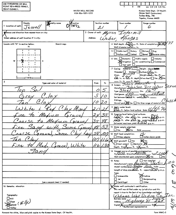
| Owner: Intermill, Myron | Status: Constructed | ||
| Location: T1S, R6W, Sec. 21, C W2 | County: Jewell | ||
| Directions: | |||
| Latitude: 39.950138 | Longitude: -98.0024624 | Datum NAD 27 | |
| Latitude: 39.9501511 | Longitude: -98.002784 | Datum NAD 83 | |
| Longitude and latitude calculated by Survey from township-range-section-quarter calls. Only good to within the quarter call accuracy. | |||
| View well on interactive map | |||
| General Info | ||
| Well Depth: 130 ft. | Elevation: ft. | |
| Static Water Level: 80 ft. | Est. Yield: 850 gpm. | |
| Comp. Date: 30-Mar-1977 | Well Use: Irrigation | |
| DWR Applic. #: | Other ID: | |
| Links | |
| No Wizard information available. | |
| View info from WIMAS Water Right Data base... | |
| Driller Info | ||
| Driller: Lawrence Williams Drilling Co., Inc. | License #: 264 | |
| Scanned Form | View scan |
|
Chemical Sample Submitted?: No
Water Well disinfected?: | ||
| Ground water encountered: 0 ft. , 0 ft. , 0 ft. | ||
| Pump test data: Well water was 0 ft after 0 hours pumping 0 gpm | ||
| Casing Info | ||
| Casing Type:
Casing Joints: |
Diam: 0 in. to 0 ft
Diam: 0 in. to 0 ft Diam: 0 in. to 0 ft | |
| Casing height above land surface: in
Casing Weight: lbs/ft Wall thickness or gauge no.: | ||
| Screen and Perforation Info | ||
| Screen Type: | Screen Openings: | |
| Screen-perforated intervals | From: 120 ft to 130 ft
From: 0 ft to 0 ft From: 0 ft to 0 ft | |
| Gravel pack intervals | From: ft to ft | |
| Grout Info | ||
| Grout used: | From: 0 to 0 ft
From: 0 to 0 ft From: 0 to 0 ft | |
| Source of Possible Contamination | ||
| Source: | ||
| Direction from well: | Distance: 0 ft | |
| Lithologic Log
(Log data entered by KGS.) | ||
| From: 0 ft. to 5 ft. | top soil | |
| From: 5 ft. to 10 ft. | gray clay | |
| From: 10 ft. to 20 ft. | tan clay | |
| From: 20 ft. to 24 ft. | white and red clay, mixed | |
| From: 24 ft. to 35 ft. | fine to medium gravel | |
| From: 35 ft. to 48 ft. | coarse to medium gravel | |
| From: 48 ft. to 53 ft. | fine sand with some gravel | |
| From: 53 ft. to 107 ft. | coarse gravel, some clay layers | |
| From: 107 ft. to 116 ft. | tan clay | |
| From: 116 ft. to 130 ft. | fine to medium gravel, white sand | |