|
|
|
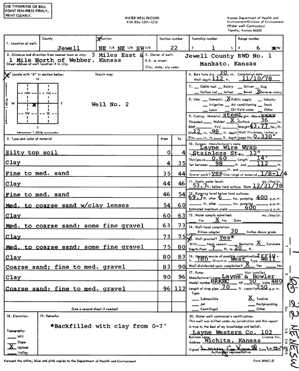
Specific Water Well Detail |
|
|
| Location Info | |||
| Owner: Jewell Co. RWD 1 | Status: Constructed | ||
| Location: T1S, R6W, Sec. 22, NE NE SW | County: Jewell | ||
| Directions: from Webber, 3 mi E and 1 mi N | |||
| Latitude: 39.9492659 | Longitude: -97.9800369 | Datum NAD 27 | |
| Latitude: 39.9492788 | Longitude: -97.9803583 | Datum NAD 83 | |
| Longitude and latitude calculated by Survey from township-range-section-quarter calls. Only good to within the quarter call accuracy. | |||
| View well on interactive map | |||
| General Info | ||
| Well Depth: 112 ft. | Elevation: ft. | |
| Static Water Level: 53.7 ft. | Est. Yield: 600 gpm. | |
| Comp. Date: 10-Nov-1978 | Well Use: Public Water Supply | |
| DWR Applic. #: | Other ID: | |
| Links | |
| No Wizard information available. | |
| View info from WIMAS Water Right Data base... | |
| Driller Info | ||
| Driller: Layne-Christensen Co. | License #: 102 | |
| Scanned Form | View scan |
|
Chemical Sample Submitted?: No
Water Well disinfected?: | ||
| Ground water encountered: 0 ft. , 0 ft. , 0 ft. | ||
| Pump test data: Well water was 0 ft after 0 hours pumping 0 gpm | ||
| Casing Info | ||
| Casing Type:
Casing Joints: |
Diam: 0 in. to 0 ft
Diam: 0 in. to 0 ft Diam: 0 in. to 0 ft | |
| Casing height above land surface: in
Casing Weight: lbs/ft Wall thickness or gauge no.: | ||
| Screen and Perforation Info | ||
| Screen Type: | Screen Openings: | |
| Screen-perforated intervals | From: 98 ft to 112 ft
From: 0 ft to 0 ft From: 0 ft to 0 ft | |
| Gravel pack intervals | From: ft to ft | |
| Grout Info | ||
| Grout used: | From: 0 to 0 ft
From: 0 to 0 ft From: 0 to 0 ft | |
| Source of Possible Contamination | ||
| Source: | ||
| Direction from well: | Distance: 0 ft | |
| Lithologic Log
(Log data entered by KGS.) | ||
| From: 0 ft. to 4 ft. | silty top soil | |
| From: 4 ft. to 35 ft. | clay | |
| From: 35 ft. to 44 ft. | fine to medium sand | |
| From: 44 ft. to 46 ft. | clay | |
| From: 46 ft. to 54 ft. | fine to medium sand | |
| From: 54 ft. to 60 ft. | medium to coarse sand with clay lenses | |
| From: 60 ft. to 63 ft. | clay | |
| From: 63 ft. to 73 ft. | medium to coarse sand; some fine gravel | |
| From: 73 ft. to 75 ft. | clay | |
| From: 75 ft. to 80 ft. | medium to coarse sand; some fine gravel | |
| From: 80 ft. to 83 ft. | clay | |
| From: 83 ft. to 90 ft. | coarse sand; fine to medium gravel | |
| From: 90 ft. to 96 ft. | clay | |
| From: 96 ft. to 112 ft. | coarse sand; fine to medium gravel | |