|
|
|
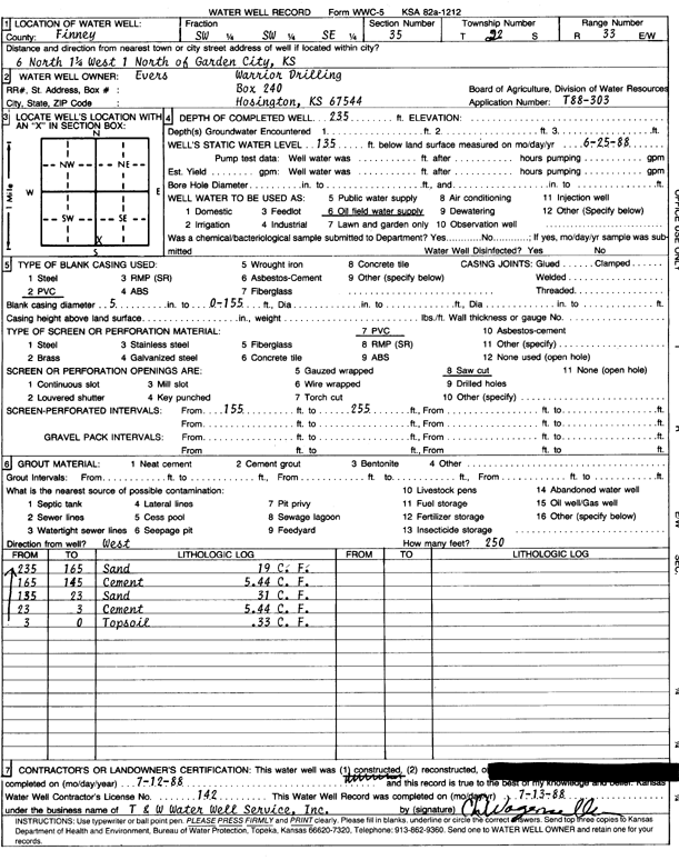
Specific Water Well Detail |
|
|
| Location Info | |||
| Owner: Warrior Drilling | Status: Plugged | ||
| Location: T22S, R33W, Sec. 35, SW SW SE | County: Finney | ||
| Directions: from Garden City, 6 mi N, 1.25 mi W, and 1 mi N | |||
| Latitude: 38.0919849 | Longitude: -100.9094677 | Datum NAD 27 | |
| Latitude: 38.0920079 | Longitude: -100.9099063 | Datum NAD 83 | |
| Longitude and latitude calculated by Survey from township-range-section-quarter calls. Only good to within the quarter call accuracy. | |||
| View well on interactive map | |||
| General Info | ||
| Well Depth: 235 ft. | Elevation: ft. | |
| Static Water Level: 135 ft. | Est. Yield: gpm. | |
| Comp. Date: 12-Jul-1988 | Well Use: Oil Field Water Supply | |
| DWR Applic. #: T88-303 | Other ID: | |
| Links | |
| No Wizard information available. | |
| View info from WIMAS Water Right Data base... | |
| Driller Info | ||
| Driller: T & W Water Well Serv., Inc. | License #: 142 | |
| Scanned Form | View scan |
| Casing Info | ||
|
Casing Type:
Diam: in. Casing height above land surface: in | ||
| Grout Info | ||
| Grout used: | From: to ft | |
| Source of Possible Contamination | ||
| Source: | ||
| Direction from well: | Distance: ft | |