|
|
|
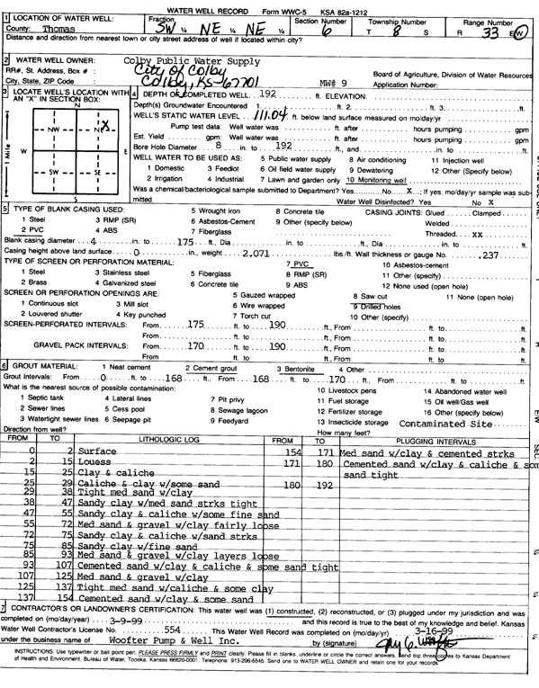
Specific Water Well Detail |
|
|
| Location Info | |||
| Owner: City of Colby | Status: Constructed | ||
| Location: T8S, R33W, Sec. 6, SW NE NE | County: Thomas | ||
| Directions: | |||
| Latitude: 39.391594 | Longitude: -101.0394725 | Datum NAD 27 | |
| Latitude: 39.3915978 | Longitude: -101.0399052 | Datum NAD 83 | |
| Longitude and latitude calculated by Survey from township-range-section-quarter calls. Only good to within the quarter call accuracy. | |||
| View well on interactive map | |||
| General Info | ||
| Well Depth: 192 ft. | Elevation: ft. | |
| Static Water Level: 111.04 ft. | Est. Yield: gpm. | |
| Comp. Date: 09-Mar-1999 | Well Use: Monitoring well/observation/piezometer | |
| DWR Applic. #: | Other ID: MW 9 | |
| Driller Info | ||
| Driller: Woofter Pump & Well Inc. | License #: 554 | |
| Scanned Form | View scan |
|
Chemical Sample Submitted?:
Water Well disinfected?: | ||
| Casing Info | ||
| Casing Type:
Casing Joints: |
Diam: in. to ft | |
| Casing height above land surface: in
Casing Weight: lbs/ft Wall thickness or gauge no.: | ||
| Screen and Perforation Info | ||
| Screen Type: | Screen Openings: | |
| Screen-perforated intervals | From: ft to ft | |
| Gravel pack intervals | From: ft to ft | |
| Grout Info | ||
| Grout used: | From: to ft | |
| Source of Possible Contamination | ||
| Source: | ||
| Direction from well: | Distance: ft | |
| Lithologic Log
(Log data entered by KGS.) | ||
| From: 0 ft. to 2 ft. | surface | |
| From: 2 ft. to 15 ft. | loess | |
| From: 15 ft. to 25 ft. | clay and caliche | |
| From: 25 ft. to 29 ft. | caliche and clay with some sand | |
| From: 29 ft. to 38 ft. | tight medium sand with clay | |
| From: 38 ft. to 47 ft. | sandy clay with medium sand streaks, tight | |
| From: 47 ft. to 55 ft. | sandy clay and caliche with some fine sand | |
| From: 55 ft. to 72 ft. | medium sand and gravel with clay, fairly loose | |
| From: 72 ft. to 75 ft. | sandy clay and caliche with sand streaks | |
| From: 75 ft. to 85 ft. | sandy clay with fine sand | |
| From: 85 ft. to 93 ft. | medium sand and gravel with clay layers, loose | |
| From: 93 ft. to 107 ft. | cemented sand with clay and caliche and some sand, tight | |
| From: 107 ft. to 125 ft. | medium sand and gravel with clay | |
| From: 125 ft. to 137 ft. | tight medium sand with caliche and some clay | |
| From: 137 ft. to 154 ft. | cemented sand with clay and some sand | |
| From: 154 ft. to 171 ft. | medium sand with clay and cemented streaks | |
| From: 171 ft. to 180 ft. | cemented sand with clay and caliche and some sand, tight | |