|
|
|
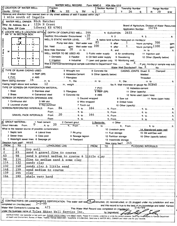
Specific Water Well Detail |
|
|
| Location Info | |||
| Owner: Hatcher, Nick | Status: Constructed | ||
| Location: T26S, R29W, Sec. 2, SW NE NW | County: Gray | ||
| Directions: from Ingalls: 1 mi S | |||
| Latitude: 37.8243688 | Longitude: -100.4638536 | Datum NAD 27 | |
| Latitude: 37.8243907 | Longitude: -100.4642799 | Datum NAD 83 | |
| Longitude and latitude calculated by Survey from township-range-section-quarter calls. Only good to within the quarter call accuracy. | |||
| View well on interactive map | |||
| General Info | ||
| Well Depth: 164 ft. | Elevation: 2655 ft. | |
| Static Water Level: 10 ft. | Est. Yield: gpm. | |
| Comp. Date: 05-May-1999 | Well Use: Irrigation | |
| DWR Applic. #: 16716 | Other ID: | |
| Links | |
| No Wizard information available. | |
| View info from WIMAS Water Right Data base... | |
| Driller Info | ||
| Driller: Tyler Water Well, Inc. | License #: 473 | |
| Scanned Form | View scan |
|
Chemical Sample Submitted?:
Water Well disinfected?: | ||
| Casing Info | ||
| Casing Type:
Casing Joints: |
Diam: in. to ft | |
| Casing height above land surface: in
Casing Weight: lbs/ft Wall thickness or gauge no.: | ||
| Screen and Perforation Info | ||
| Screen Type: | Screen Openings: | |
| Screen-perforated intervals | From: ft to ft | |
| Gravel pack intervals | From: ft to ft | |
| Grout Info | ||
| Grout used: | From: to ft | |
| Source of Possible Contamination | ||
| Source: | ||
| Direction from well: | Distance: ft | |
| Lithologic Log
(Log data entered by KGS.) | ||
| From: 0 ft. to 2 ft. | top soil | |
| From: 2 ft. to 65 ft. | fine to coarse sand and gravel | |
| From: 65 ft. to 98 ft. | medium to coarse sand and gravel and little clay | |
| From: 98 ft. to 114 ft. | fine to medium sand and some clay | |
| From: 114 ft. to 132 ft. | sandy clay | |
| From: 132 ft. to 148 ft. | sandy clay and little sand | |
| From: 148 ft. to 159 ft. | medium to coarse sand | |
| From: 159 ft. to 164 ft. | clay | |
| From: 164 ft. to 180 ft. | shale very hard | |