|
|
|
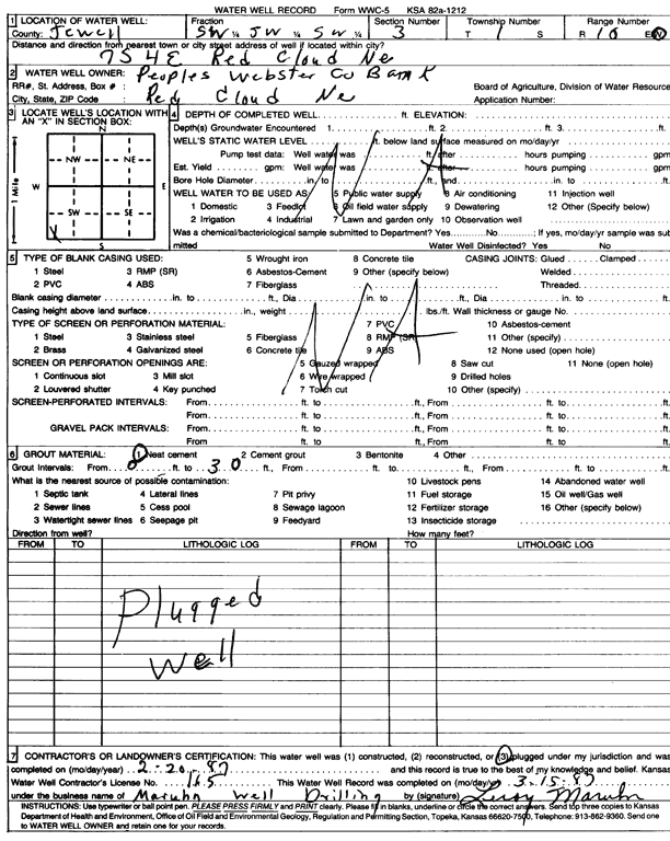
Specific Water Well Detail |
|
|
| Location Info | |||
| Owner: Peoples Webster County Bank | Status: Plugged | ||
| Location: T1S, R10W, Sec. 3, SW SW SW | County: Jewell | ||
| Directions: from Red Cloud, NE, 7 mi S and 4 mi E | |||
| Latitude: 39.9885624 | Longitude: -98.4468876 | Datum NAD 27 | |
| Latitude: 39.988576 | Longitude: -98.4472217 | Datum NAD 83 | |
| Longitude and latitude calculated by Survey from township-range-section-quarter calls. Only good to within the quarter call accuracy. | |||
| View well on interactive map | |||
| General Info | ||
| Well Depth: ft. | Elevation: ft. | |
| Static Water Level: ft. | Est. Yield: gpm. | |
| Comp. Date: 20-Feb-1987 | Well Use: (unstated)/abandoned | |
| DWR Applic. #: | Other ID: | |
| Driller Info | ||
| Driller: Leroy Maruhn Well Drilling, Inc. | License #: 165 | |
| Scanned Form | View scan |
| Casing Info | ||
|
Casing Type:
Diam: 0 in. Casing height above land surface: in | ||
| Grout Info | ||
| Grout used: Neat cement | From: 0 to 30 ft
From: 0 to 0 ft From: 0 to 0 ft | |
| Source of Possible Contamination | ||
| Source: | ||
| Direction from well: | Distance: 0 ft | |