|
|
|
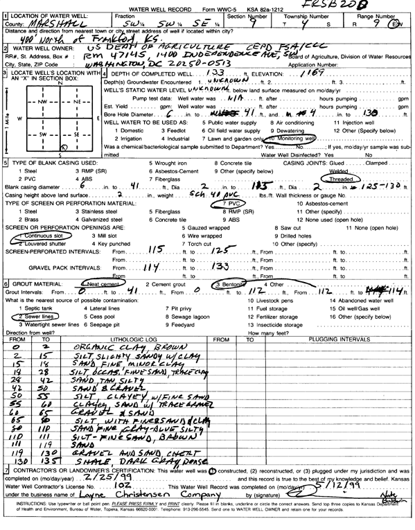
Specific Water Well Detail |
|
|
| Location Info | |||
| Owner: U.S. Dept. of Agriculture | Status: Constructed | ||
| Location: T4S, R9E, Sec. 9, SW SW SE | County: Marshall | ||
| Directions: from Frankfort: 400' N | |||
| Latitude: 39.7121099 | Longitude: -96.4155469 | Datum NAD 27 | |
| Latitude: 39.7121093 | Longitude: -96.415836 | Datum NAD 83 | |
| Longitude and latitude calculated by Survey from township-range-section-quarter calls. Only good to within the quarter call accuracy. | |||
| View well on interactive map | |||
| General Info | ||
| Well Depth: 133 ft. | Elevation: 1169 ft. | |
| Static Water Level: ft. | Est. Yield: gpm. | |
| Comp. Date: 25-Feb-1999 | Well Use: Monitoring well/observation/piezometer | |
| DWR Applic. #: | Other ID: FRSB 20D | |
| Driller Info | ||
| Driller: Layne-Christensen Co. | License #: 102 | |
| Scanned Form | View scan |
|
Chemical Sample Submitted?:
Water Well disinfected?: | ||
| Casing Info | ||
| Casing Type:
Casing Joints: |
Diam: in. to ft | |
| Casing height above land surface: in
Casing Weight: lbs/ft Wall thickness or gauge no.: | ||
| Screen and Perforation Info | ||
| Screen Type: | Screen Openings: | |
| Screen-perforated intervals | From: ft to ft | |
| Gravel pack intervals | From: ft to ft | |
| Grout Info | ||
| Grout used: | From: to ft | |
| Source of Possible Contamination | ||
| Source: | ||
| Direction from well: | Distance: ft | |
| Lithologic Log
(Log data entered by KGS.) | ||
| From: 0 ft. to 2 ft. | organic clay, brown | |
| From: 2 ft. to 15 ft. | slightly sandy silt with clay | |
| From: 15 ft. to 18 ft. | fine sand with minor clay | |
| From: 18 ft. to 28 ft. | silt with occasional fine sand and trace clay | |
| From: 28 ft. to 42 ft. | silty sand, tan | |
| From: 42 ft. to 50 ft. | sand and gravel | |
| From: 50 ft. to 55 ft. | clayey silt with fine sand | |
| From: 55 ft. to 60 ft. | clay sand with trace gravel | |
| From: 60 ft. to 65 ft. | gravel and sand | |
| From: 65 ft. to 80 ft. | silt with fine sand and clay | |
| From: 80 ft. to 110 ft. | fine sand, gray-blue, silty | |
| From: 110 ft. to 111 ft. | silt and fine sand, brown | |
| From: 111 ft. to 119 ft. | sand | |
| From: 119 ft. to 130 ft. | gravel and sand with chert | |
| From: 130 ft. to 135 ft. | shale, dark gray, dense | |