|
|
|
Specific Water Well Detail |
|
|
| Location Info | |||
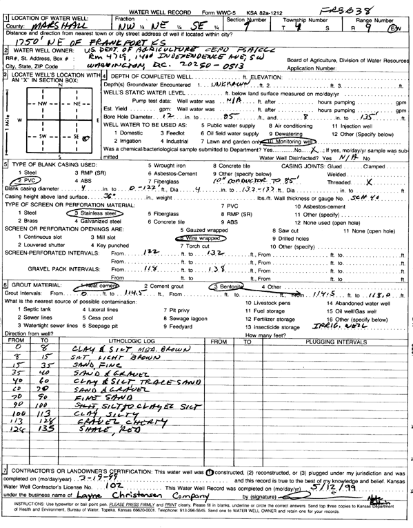
| Owner: U.S. Dept. of Agriculture | Status: Constructed | ||
| Location: T4S, R9E, Sec. 9, NW NE SE | County: Marshall | ||
| Directions: from Frankfort: 1750 feet NE | |||
| Latitude: 39.7176071 | Longitude: -96.4108531 | Datum NAD 27 | |
| Latitude: 39.7176065 | Longitude: -96.4111422 | Datum NAD 83 | |
| Longitude and latitude calculated by Survey from township-range-section-quarter calls. Only good to within the quarter call accuracy. | |||
| View well on interactive map | |||
| General Info | ||
| Well Depth: ft. | Elevation: ft. | |
| Static Water Level: ft. | Est. Yield: gpm. | |
| Comp. Date: 19-Mar-1999 | Well Use: Monitoring well/observation/piezometer | |
| DWR Applic. #: | Other ID: FRSB 38 | |
| Driller Info | ||
| Driller: Layne-Christensen Co. | License #: 102 | |
| Scanned Form | View scan |
|
Chemical Sample Submitted?:
Water Well disinfected?: | ||
| Casing Info | ||
| Casing Type:
Casing Joints: |
Diam: in. to ft | |
| Casing height above land surface: in
Casing Weight: lbs/ft Wall thickness or gauge no.: | ||
| Screen and Perforation Info | ||
| Screen Type: | Screen Openings: | |
| Screen-perforated intervals | From: ft to ft | |
| Gravel pack intervals | From: ft to ft | |
| Grout Info | ||
| Grout used: | From: to ft | |
| Source of Possible Contamination | ||
| Source: | ||
| Direction from well: | Distance: ft | |
| Lithologic Log
(Log data entered by KGS.) | ||
| From: 0 ft. to 8 ft. | clay and silt, medium brown | |
| From: 8 ft. to 15 ft. | silt, light brown | |
| From: 15 ft. to 35 ft. | fine sand | |
| From: 35 ft. to 40 ft. | sand and gravel | |
| From: 40 ft. to 60 ft. | clay and silt with trace sand | |
| From: 60 ft. to 70 ft. | sand and gravel | |
| From: 70 ft. to 90 ft. | fine sand | |
| From: 90 ft. to 100 ft. | silt to clayey silt | |
| From: 100 ft. to 113 ft. | silty clay | |
| From: 113 ft. to 128 ft. | cherty gravel | |
| From: 128 ft. to 135 ft. | shale, red | |