|
|
|
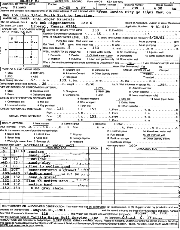
Specific Water Well Detail |
|
|
| Location Info | |||
| Owner: Challenger Minerals | Status: Constructed | ||
| Location: T23S, R30W, Sec. 7, C NW NW | County: Finney | ||
| Directions: from Garden City, 11.5 mi E on Hwy 156 then 0.75 mi NE | |||
| Latitude: 38.073251 | Longitude: -100.6614616 | Datum NAD 27 | |
| Latitude: 38.0732719 | Longitude: -100.6618918 | Datum NAD 83 | |
| Longitude and latitude calculated by Survey from township-range-section-quarter calls. Only good to within the quarter call accuracy. | |||
| View well on interactive map | |||
| General Info | ||
| Well Depth: 158 ft. | Elevation: ft. | |
| Static Water Level: 93 ft. | Est. Yield: gpm. | |
| Comp. Date: 20-Aug-1981 | Well Use: Oil Field Water Supply | |
| DWR Applic. #: T81-510 | Other ID: Bulger 1 | |
| Driller Info | ||
| Driller: Catlile Water Well Service, In | License #: 118 | |
| Scanned Form | View scan |
|
Chemical Sample Submitted?:
Water Well disinfected?: | ||
| Casing Info | ||
| Casing Type:
Casing Joints: |
Diam: in. to ft | |
| Casing height above land surface: in
Casing Weight: lbs/ft Wall thickness or gauge no.: | ||
| Screen and Perforation Info | ||
| Screen Type: | Screen Openings: | |
| Screen-perforated intervals | From: ft to ft | |
| Gravel pack intervals | From: ft to ft | |
| Grout Info | ||
| Grout used: | From: to ft | |
| Source of Possible Contamination | ||
| Source: | ||
| Direction from well: | Distance: ft | |
| Lithologic Log
(Log data entered by KGS.) | ||
| From: 0 ft. to 3 ft. | surface | |
| From: 3 ft. to 20 ft. | sandy clay | |
| From: 20 ft. to 42 ft. | caliche | |
| From: 42 ft. to 73 ft. | sandy clay | |
| From: 73 ft. to 85 ft. | fine to medium sand | |
| From: 85 ft. to 103 ft. | cemented sand and gravel | |
| From: 103 ft. to 120 ft. | medium sand | |
| From: 120 ft. to 132 ft. | sand and gravel | |
| From: 132 ft. to 140 ft. | fine to medium sand | |
| From: 140 ft. to 152 ft. | medium sand | |
| From: 152 ft. to 158 ft. | blue gray shale | |