|
|
|
Specific Water Well Detail |
|
|
| Location Info | |||
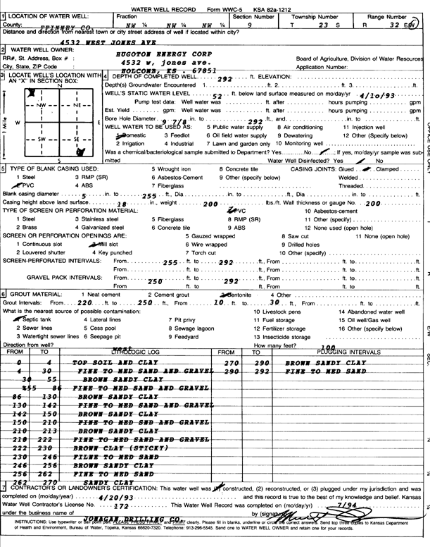
| Owner: Hugoton Energy Corporation | Status: Constructed | ||
| Location: T23S, R32W, Sec. 9, NW NW NW | County: Finney | ||
| Directions: 4532 W Jones Ave | |||
| Latitude: 38.0753661 | Longitude: -100.8457316 | Datum NAD 27 | |
| Latitude: 38.0753886 | Longitude: -100.8461684 | Datum NAD 83 | |
| Longitude and latitude calculated by Survey from township-range-section-quarter calls. Only good to within the quarter call accuracy. | |||
| View well on interactive map | |||
| General Info | ||
| Well Depth: 292 ft. | Elevation: ft. | |
| Static Water Level: 52 ft. | Est. Yield: gpm. | |
| Comp. Date: 20-Apr-1993 | Well Use: Domestic | |
| DWR Applic. #: | Other ID: | |
| Driller Info | ||
| Driller: Jonagan Drilling Company | License #: 172 | |
| Scanned Form | View scan |
|
Chemical Sample Submitted?:
Water Well disinfected?: | ||
| Casing Info | ||
| Casing Type:
Casing Joints: |
Diam: in. to ft | |
| Casing height above land surface: in
Casing Weight: lbs/ft Wall thickness or gauge no.: | ||
| Screen and Perforation Info | ||
| Screen Type: | Screen Openings: | |
| Screen-perforated intervals | From: ft to ft | |
| Gravel pack intervals | From: ft to ft | |
| Grout Info | ||
| Grout used: | From: to ft | |
| Source of Possible Contamination | ||
| Source: | ||
| Direction from well: | Distance: ft | |
| Lithologic Log
(Log data entered by KGS.) | ||
| From: 0 ft. to 4 ft. | top soil and clay | |
| From: 4 ft. to 30 ft. | fine to medium sand and gravel | |
| From: 30 ft. to 55 ft. | brown sandy clay | |
| From: 55 ft. to 86 ft. | fine to medium sand and gravel | |
| From: 86 ft. to 130 ft. | brown sandy clay | |
| From: 130 ft. to 142 ft. | fine to medium sand and gravel | |
| From: 142 ft. to 150 ft. | brown sandy clay | |
| From: 150 ft. to 210 ft. | fine to med sand and gravel | |
| From: 210 ft. to 213 ft. | brown sandy clay | |
| From: 213 ft. to 222 ft. | fine to medium sand and gravel | |
| From: 222 ft. to 230 ft. | brown clay (sticky) | |
| From: 230 ft. to 246 ft. | fine to medium sand | |
| From: 246 ft. to 256 ft. | brown sandy clay | |
| From: 256 ft. to 262 ft. | fine to medium sand | |
| From: 262 ft. to 270 ft. | sandy clay | |
| From: 270 ft. to 290 ft. | brown sandy clay | |
| From: 290 ft. to 292 ft. | fine to medium sand | |