|
|
|
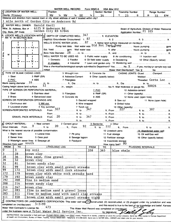
Specific Water Well Detail |
|
|
| Location Info | |||
| Owner: Knoll, Harold | Status: Constructed | ||
| Location: T23S, R33W, Sec. 34, NW NW SE | County: Finney | ||
| Directions: 1 mi N of Garden City on Anderson Road | |||
| Latitude: 38.0101374 | Longitude: -100.9278872 | Datum NAD 27 | |
| Latitude: 38.0101609 | Longitude: -100.9283286 | Datum NAD 83 | |
| Longitude and latitude calculated by Survey from township-range-section-quarter calls. Only good to within the quarter call accuracy. | |||
| View well on interactive map | |||
| General Info | ||
| Well Depth: 347 ft. | Elevation: ft. | |
| Static Water Level: 87 ft. | Est. Yield: gpm. | |
| Comp. Date: 03-May-1999 | Well Use: Irrigation | |
| DWR Applic. #: FI 105 | Other ID: | |
| Links | |
| No Wizard information available. | |
| View info from WIMAS Water Right Data base... | |
| Driller Info | ||
| Driller: Tyler Water Well Service, Inc. | License #: 473 | |
| Scanned Form | View scan |
|
Chemical Sample Submitted?:
Water Well disinfected?: | ||
| Casing Info | ||
| Casing Type:
Casing Joints: |
Diam: in. to ft | |
| Casing height above land surface: in
Casing Weight: lbs/ft Wall thickness or gauge no.: | ||
| Screen and Perforation Info | ||
| Screen Type: | Screen Openings: | |
| Screen-perforated intervals | From: ft to ft | |
| Gravel pack intervals | From: ft to ft | |
| Grout Info | ||
| Grout used: | From: to ft | |
| Source of Possible Contamination | ||
| Source: | ||
| Direction from well: | Distance: ft | |
| Lithologic Log
(Log data entered by KGS.) | ||
| From: 0 ft. to 3 ft. | top soil | |
| From: 3 ft. to 28 ft. | brown clay | |
| From: 28 ft. to 36 ft. | fine sand, fine gravel | |
| From: 36 ft. to 52 ft. | brown clay | |
| From: 52 ft. to 81 ft. | brown sandy clay | |
| From: 81 ft. to 99 ft. | brown clay with small gravel streaks | |
| From: 99 ft. to 172 ft. | brown clay with small rock streaks | |
| From: 172 ft. to 179 ft. | brown clay with white rock streaks hard | |
| From: 179 ft. to 192 ft. | brown sandy clay | |
| From: 192 ft. to 208 ft. | fine to medium sand | |
| From: 208 ft. to 214 ft. | brown sandy clay | |
| From: 214 ft. to 247 ft. | brown clay | |
| From: 247 ft. to 283 ft. | fine to medium sand and gravel loose | |
| From: 283 ft. to 311 ft. | fine to medium sand with small clay streaks | |
| From: 311 ft. to 358 ft. | brown clay with small gravel streaks tight | |
| From: 358 ft. to 365 ft. | blue shale | |