|
|
|
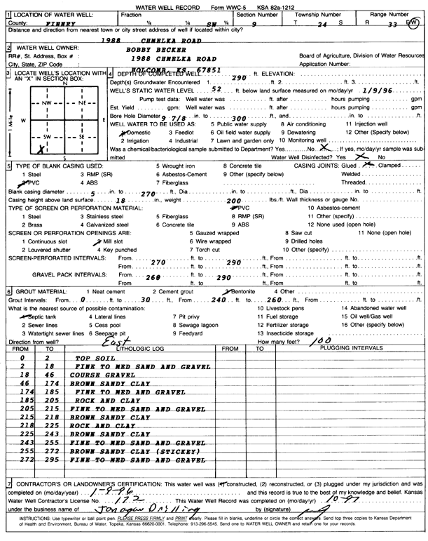
Specific Water Well Detail |
|
|
| Location Info | |||
| Owner: Becker, Bobby | Status: Constructed | ||
| Location: T24S, R33W, Sec. 9, SW | County: Finney | ||
| Directions: 1988 Chmelka Road, Holcomb | |||
| Latitude: 37.9782343 | Longitude: -100.9518242 | Datum NAD 27 | |
| Latitude: 37.9782581 | Longitude: -100.952267 | Datum NAD 83 | |
| Longitude and latitude calculated by Survey from township-range-section-quarter calls. Only good to within the quarter call accuracy. | |||
| View well on interactive map | |||
| General Info | ||
| Well Depth: 290 ft. | Elevation: ft. | |
| Static Water Level: 52 ft. | Est. Yield: gpm. | |
| Comp. Date: 09-Jan-1966 | Well Use: Domestic | |
| DWR Applic. #: | Other ID: | |
| Driller Info | ||
| Driller: Jonagan Drilling | License #: 172 | |
| Scanned Form | View scan |
|
Chemical Sample Submitted?:
Water Well disinfected?: | ||
| Casing Info | ||
| Casing Type:
Casing Joints: |
Diam: in. to ft | |
| Casing height above land surface: in
Casing Weight: lbs/ft Wall thickness or gauge no.: | ||
| Screen and Perforation Info | ||
| Screen Type: | Screen Openings: | |
| Screen-perforated intervals | From: ft to ft | |
| Gravel pack intervals | From: ft to ft | |
| Grout Info | ||
| Grout used: | From: to ft | |
| Source of Possible Contamination | ||
| Source: | ||
| Direction from well: | Distance: ft | |
| Lithologic Log
(Log data entered by KGS.) | ||
| From: 0 ft. to 2 ft. | top soil | |
| From: 2 ft. to 18 ft. | fine to medium sand and gravel | |
| From: 18 ft. to 46 ft. | coarse gravel | |
| From: 46 ft. to 174 ft. | brown sandy clay | |
| From: 174 ft. to 185 ft. | fine to med and gravel | |
| From: 185 ft. to 205 ft. | rock and clay | |
| From: 205 ft. to 215 ft. | fine to medium sand and gravel | |
| From: 215 ft. to 218 ft. | brown sandy clay | |
| From: 218 ft. to 225 ft. | rock and clay | |
| From: 225 ft. to 243 ft. | brown sandy clay | |
| From: 243 ft. to 255 ft. | fine to medium sand and gravel | |
| From: 255 ft. to 272 ft. | brown sandy clay (sticky) | |
| From: 272 ft. to 295 ft. | fine to medium sand and gravel | |