|
|
|
Specific Water Well Detail |
|
|
| Location Info | |||
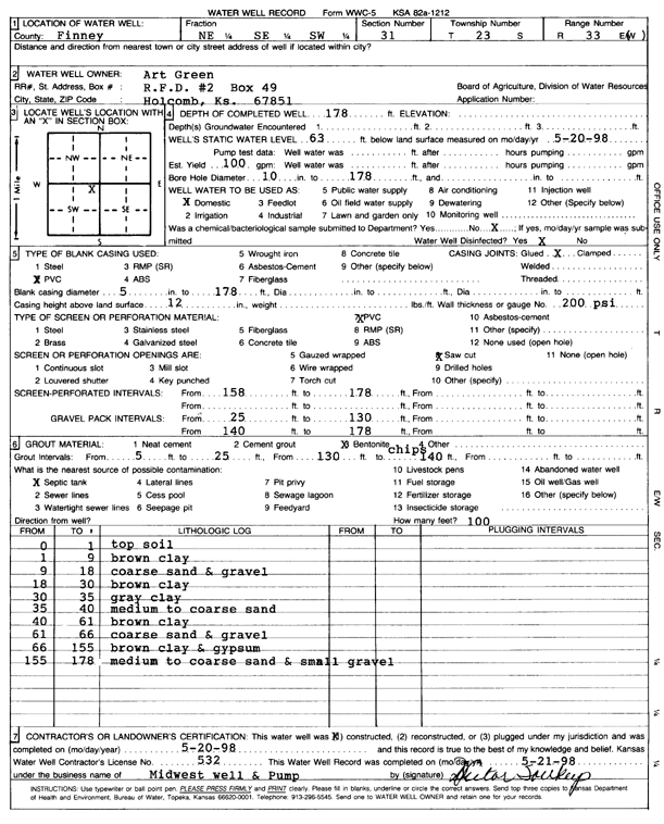
| Owner: Green, Art | Status: Constructed | ||
| Location: T23S, R33W, Sec. 31, NE SE SW | County: Finney | ||
| Directions: | |||
| Latitude: 38.006299 | Longitude: -100.985068 | Datum NAD 27 | |
| Latitude: 38.0063232 | Longitude: -100.9855117 | Datum NAD 83 | |
| Longitude and latitude calculated by Survey from township-range-section-quarter calls. Only good to within the quarter call accuracy. | |||
| View well on interactive map | |||
| General Info | ||
| Well Depth: 178 ft. | Elevation: ft. | |
| Static Water Level: 63 ft. | Est. Yield: gpm. | |
| Comp. Date: 20-May-1998 | Well Use: Domestic | |
| DWR Applic. #: | Other ID: | |
| Driller Info | ||
| Driller: Midwest Well & Pump, Inc. | License #: 532 | |
| Scanned Form | View scan |
|
Chemical Sample Submitted?:
Water Well disinfected?: | ||
| Casing Info | ||
| Casing Type:
Casing Joints: |
Diam: in. to ft | |
| Casing height above land surface: in
Casing Weight: lbs/ft Wall thickness or gauge no.: | ||
| Screen and Perforation Info | ||
| Screen Type: | Screen Openings: | |
| Screen-perforated intervals | From: ft to ft | |
| Gravel pack intervals | From: ft to ft | |
| Grout Info | ||
| Grout used: | From: to ft | |
| Source of Possible Contamination | ||
| Source: | ||
| Direction from well: | Distance: ft | |
| Lithologic Log
(Log data entered by KGS.) | ||
| From: 0 ft. to 1 ft. | top soil | |
| From: 1 ft. to 9 ft. | brown clay | |
| From: 9 ft. to 18 ft. | coarse sand and gravel | |
| From: 18 ft. to 30 ft. | brown clay | |
| From: 30 ft. to 35 ft. | gray clay | |
| From: 35 ft. to 40 ft. | medium to coarse sand | |
| From: 40 ft. to 61 ft. | brown clay | |
| From: 61 ft. to 66 ft. | coarse sand and gravel | |
| From: 66 ft. to 155 ft. | brown clay and gypsum | |
| From: 155 ft. to 178 ft. | medium to coarse sand and small gravel | |