|
|
|
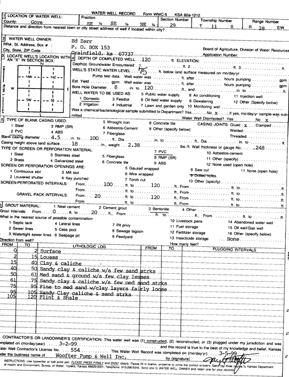
Specific Water Well Detail |
|
|
| Location Info | |||
| Owner: Zerr, Ed | Status: Constructed | ||
| Location: T11S, R28W, Sec. 29, SE SE NE | County: Gove | ||
| Directions: | |||
| Latitude: 39.0691299 | Longitude: -100.4456007 | Datum NAD 27 | |
| Latitude: 39.0691379 | Longitude: -100.4460162 | Datum NAD 83 | |
| Longitude and latitude calculated by Survey from township-range-section-quarter calls. Only good to within the quarter call accuracy. | |||
| View well on interactive map | |||
| General Info | ||
| Well Depth: 120 ft. | Elevation: ft. | |
| Static Water Level: 75 ft. | Est. Yield: gpm. | |
| Comp. Date: 02-Mar-1999 | Well Use: Domestic | |
| DWR Applic. #: | Other ID: | |
| Driller Info | ||
| Driller: Woofter Pump & Well, Inc. | License #: 554 | |
| Scanned Form | View scan |
|
Chemical Sample Submitted?:
Water Well disinfected?: | ||
| Casing Info | ||
| Casing Type:
Casing Joints: |
Diam: in. to ft | |
| Casing height above land surface: in
Casing Weight: lbs/ft Wall thickness or gauge no.: | ||
| Screen and Perforation Info | ||
| Screen Type: | Screen Openings: | |
| Screen-perforated intervals | From: ft to ft | |
| Gravel pack intervals | From: ft to ft | |
| Grout Info | ||
| Grout used: | From: to ft | |
| Source of Possible Contamination | ||
| Source: | ||
| Direction from well: | Distance: ft | |
| Lithologic Log
(Log data entered by KGS.) | ||
| From: 0 ft. to 2 ft. | Surface | |
| From: 2 ft. to 15 ft. | Loess | |
| From: 15 ft. to 40 ft. | Clay and caliche | |
| From: 40 ft. to 50 ft. | Sandy clay and caliche with a few sand streaks | |
| From: 50 ft. to 61 ft. | Medium sand and ground with a few clay lenses | |
| From: 61 ft. to 75 ft. | Sandy clay and caliche with a few medium sand streaks | |
| From: 75 ft. to 95 ft. | Fine to medium sand with clay layers fairly loose | |
| From: 95 ft. to 105 ft. | Sandy clay caliche and sand streaks | |
| From: 105 ft. to 120 ft. | Flint and shale | |