|
|
|
Specific Water Well Detail |
|
|
| Location Info | |||
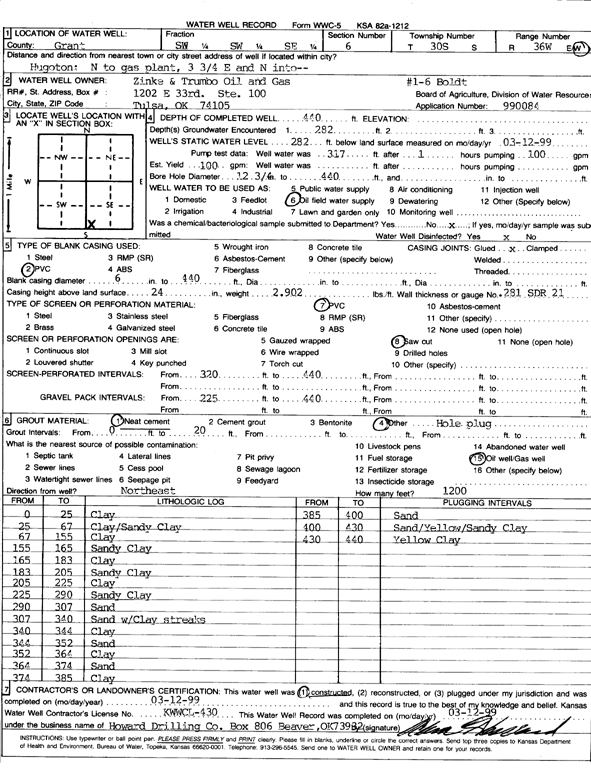
| Owner: Zinke and Trumbo Oil and Gas | Status: Constructed | ||
| Location: T30S, R36W, Sec. 6, SW SW SE | County: Grant | ||
| Directions: from Hugoton: N to gas plant, 3.75 mi E, N into loctation | |||
| Latitude: 37.461153 | Longitude: -101.2968452 | Datum NAD 27 | |
| Latitude: 37.4611761 | Longitude: -101.29729 | Datum NAD 83 | |
| Longitude and latitude calculated by Survey from township-range-section-quarter calls. Only good to within the quarter call accuracy. | |||
| View well on interactive map | |||
| General Info | ||
| Well Depth: 440 ft. | Elevation: ft. | |
| Static Water Level: 282 ft. | Est. Yield: 100 gpm. | |
| Comp. Date: 12-Mar-1999 | Well Use: Oil Field Water Supply | |
| DWR Applic. #: 990084 | Other ID: Boldt 1-6 | |
| Links | |
| No Wizard information available. | |
| View info from WIMAS Water Right Data base... | |
| Driller Info | ||
| Driller: Howard Drilling Company AG, LLC | License #: 430 | |
| Scanned Form | View scan |
|
Chemical Sample Submitted?:
Water Well disinfected?: | ||
| Casing Info | ||
| Casing Type:
Casing Joints: |
Diam: in. to ft | |
| Casing height above land surface: in
Casing Weight: lbs/ft Wall thickness or gauge no.: | ||
| Screen and Perforation Info | ||
| Screen Type: | Screen Openings: | |
| Screen-perforated intervals | From: ft to ft | |
| Gravel pack intervals | From: ft to ft | |
| Grout Info | ||
| Grout used: | From: to ft | |
| Source of Possible Contamination | ||
| Source: | ||
| Direction from well: | Distance: ft | |
| Lithologic Log
(Log data entered by KGS.) | ||
| From: 0 ft. to 25 ft. | Clay | |
| From: 25 ft. to 67 ft. | Clay/Sandy Clay | |
| From: 67 ft. to 155 ft. | Clay | |
| From: 155 ft. to 165 ft. | Sandy Clay | |
| From: 165 ft. to 183 ft. | Clay | |
| From: 183 ft. to 205 ft. | Sandy Clay | |
| From: 205 ft. to 225 ft. | Clay | |
| From: 225 ft. to 290 ft. | Sandy Clay | |
| From: 290 ft. to 307 ft. | Sand | |
| From: 307 ft. to 340 ft. | Sand with Clay streaks | |
| From: 340 ft. to 344 ft. | Clay | |
| From: 344 ft. to 352 ft. | Sand | |
| From: 352 ft. to 364 ft. | Clay | |
| From: 364 ft. to 374 ft. | Sand | |
| From: 374 ft. to 385 ft. | Clay | |
| From: 385 ft. to 400 ft. | Sand | |
| From: 400 ft. to 430 ft. | Sand/Yellow/Sandy Clay | |
| From: 430 ft. to 440 ft. | Yellow Clay | |