|
|
|
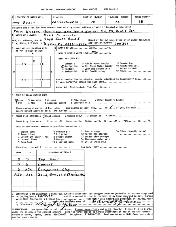
Specific Water Well Detail |
|
|
| Location Info | |||
| Owner: Johnson, David A. | Status: Plugged | ||
| Location: T30S, R38W, Sec. 10, NW NW NE | County: Grant | ||
| Directions: from Ulysses Jct 160 and 25: 5 mi W, 8 mi S, .5 mi W, .125 mi S | |||
| Latitude: 37.4597197 | Longitude: -101.4604583 | Datum NAD 27 | |
| Latitude: 37.4597415 | Longitude: -101.4609023 | Datum NAD 83 | |
| Longitude and latitude calculated by Survey from township-range-section-quarter calls. Only good to within the quarter call accuracy. | |||
| View well on interactive map | |||
| General Info | ||
| Well Depth: 300 ft. | Elevation: ft. | |
| Static Water Level: 250 ft. | Est. Yield: gpm. | |
| Comp. Date: 15-Feb-1999 | Well Use: Irrigation | |
| DWR Applic. #: 000391 | Other ID: | |
| Links | |
| View info from Wizard Water Level Data base... | |
| View info from WIMAS Water Right Data base... | |
| Driller Info | ||
| Driller: Johnson, David A. | License #: | |
| Scanned Form | View scan |
| Casing Info | ||
|
Casing Type:
Diam: in. Casing height above land surface: in | ||
| Grout Info | ||
| Grout used: | From: to ft | |
| Source of Possible Contamination | ||
| Source: | ||
| Direction from well: | Distance: ft | |