|
|
|
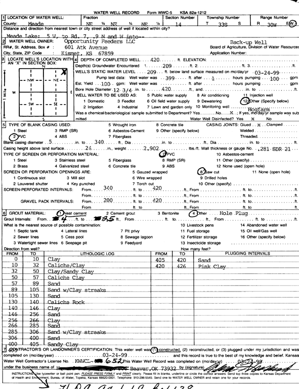
Specific Water Well Detail |
|
|
| Location Info | |||
| Owner: Opportunity Feeders LLC | Status: Constructed | ||
| Location: T33S, R30W, Sec. 14, NE NE NE | County: Meade | ||
| Directions: from Meade Lake: 5 mi W to Rd. 7, .9 mi N, W into site | |||
| Latitude: 37.1833479 | Longitude: -100.5450129 | Datum NAD 27 | |
| Latitude: 37.1833711 | Longitude: -100.5454423 | Datum NAD 83 | |
| Longitude and latitude calculated by Survey from township-range-section-quarter calls. Only good to within the quarter call accuracy. | |||
| View well on interactive map | |||
| General Info | ||
| Well Depth: 420 ft. | Elevation: ft. | |
| Static Water Level: 209 ft. | Est. Yield: 100 gpm. | |
| Comp. Date: 24-Mar-1999 | Well Use: Feedlot | |
| DWR Applic. #: | Other ID: | |
| Links | |
| No Wizard information available. | |
| View info from WIMAS Water Right Data base... | |
| Driller Info | ||
| Driller: Howard Drilling Company | License #: 652 | |
| Scanned Form | View scan |
|
Chemical Sample Submitted?:
Water Well disinfected?: | ||
| Casing Info | ||
| Casing Type:
Casing Joints: |
Diam: in. to ft | |
| Casing height above land surface: in
Casing Weight: lbs/ft Wall thickness or gauge no.: | ||
| Screen and Perforation Info | ||
| Screen Type: | Screen Openings: | |
| Screen-perforated intervals | From: ft to ft | |
| Gravel pack intervals | From: ft to ft | |
| Grout Info | ||
| Grout used: | From: to ft | |
| Source of Possible Contamination | ||
| Source: | ||
| Direction from well: | Distance: ft | |
| Lithologic Log
(Log data entered by KGS.) | ||
| From: 0 ft. to 10 ft. | clay | |
| From: 10 ft. to 32 ft. | caliche/clay | |
| From: 32 ft. to 50 ft. | clay/sandy clay | |
| From: 50 ft. to 57 ft. | caliche clay | |
| From: 57 ft. to 89 ft. | sand | |
| From: 89 ft. to 105 ft. | sand with clay streaks | |
| From: 105 ft. to 130 ft. | sand | |
| From: 130 ft. to 140 ft. | caliche rock | |
| From: 140 ft. to 146 ft. | clay | |
| From: 146 ft. to 256 ft. | sand | |
| From: 256 ft. to 266 ft. | clay | |
| From: 266 ft. to 285 ft. | sand | |
| From: 285 ft. to 306 ft. | sand with clay streaks | |
| From: 306 ft. to 400 ft. | sand | |
| From: 400 ft. to 405 ft. | sandy clay | |
| From: 405 ft. to 420 ft. | sand | |
| From: 420 ft. to 426 ft. | pink clay | |