|
|
|
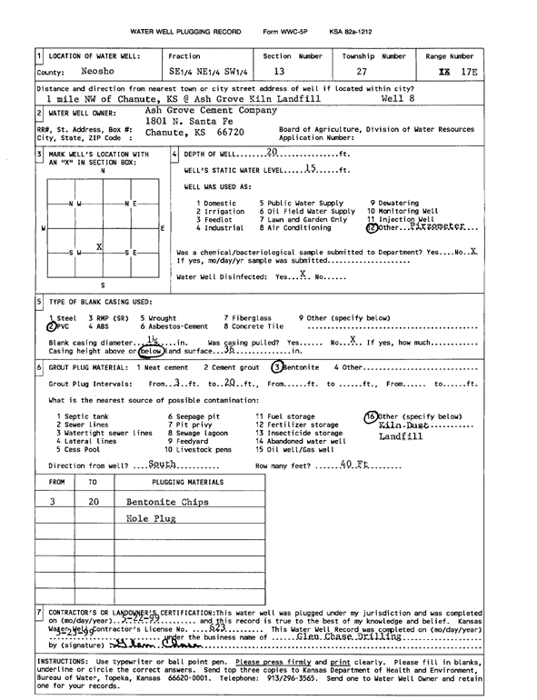
Specific Water Well Detail |
|
|
| Location Info | |||
| Owner: Ash Grove Cement Co. | Status: Plugged | ||
| Location: T27S, R17E, Sec. 13, SE NE SW | County: Neosho | ||
| Directions: from Chanute: 1.5 mi NW, Ash Grove Kiln Landfill | |||
| Latitude: 37.6937382 | Longitude: -95.4989859 | Datum NAD 27 | |
| Latitude: 37.6937844 | Longitude: -95.4992453 | Datum NAD 83 | |
| Longitude and latitude calculated by Survey from township-range-section-quarter calls. Only good to within the quarter call accuracy. | |||
| View well on interactive map | |||
| General Info | ||
| Well Depth: 20 ft. | Elevation: ft. | |
| Static Water Level: 15 ft. | Est. Yield: gpm. | |
| Comp. Date: 22-May-1999 | Well Use: Monitoring well/observation/piezometer | |
| DWR Applic. #: | Other ID: Well 8 | |
| Driller Info | ||
| Driller: Glen Chase Drilling | License #: 623 | |
| Scanned Form | View scan |
| Casing Info | ||
|
Casing Type:
Diam: in. Casing height above land surface: in | ||
| Grout Info | ||
| Grout used: | From: to ft | |
| Source of Possible Contamination | ||
| Source: | ||
| Direction from well: | Distance: ft | |