|
|
|
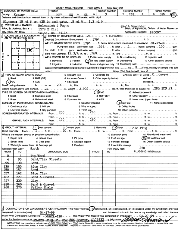
Specific Water Well Detail |
|
|
| Location Info | |||
| Owner: Helmerich & Payne Inc. | Status: Constructed | ||
| Location: T26S, R37W, Sec. 3, NE SW NE | County: Kearny | ||
| Directions: from Ulysses: 15 mi N on Hwy 25 to red gate, .5 mi W, 1.3 mi N | |||
| Latitude: 37.8221075 | Longitude: -101.3508201 | Datum NAD 27 | |
| Latitude: 37.8221248 | Longitude: -101.3512691 | Datum NAD 83 | |
| Longitude and latitude calculated by Survey from township-range-section-quarter calls. Only good to within the quarter call accuracy. | |||
| View well on interactive map | |||
| General Info | ||
| Well Depth: 260 ft. | Elevation: ft. | |
| Static Water Level: 179 ft. | Est. Yield: 100 gpm. | |
| Comp. Date: 27-Apr-1999 | Well Use: Oil Field Water Supply | |
| DWR Applic. #: 990097 | Other ID: A 1A Waechter | |
| Links | |
| No Wizard information available. | |
| View info from WIMAS Water Right Data base... | |
| Driller Info | ||
| Driller: Howard Drilling Company AG, LLC | License #: 430 | |
| Scanned Form | View scan |
|
Chemical Sample Submitted?:
Water Well disinfected?: | ||
| Casing Info | ||
| Casing Type:
Casing Joints: |
Diam: in. to ft | |
| Casing height above land surface: in
Casing Weight: lbs/ft Wall thickness or gauge no.: | ||
| Screen and Perforation Info | ||
| Screen Type: | Screen Openings: | |
| Screen-perforated intervals | From: ft to ft | |
| Gravel pack intervals | From: ft to ft | |
| Grout Info | ||
| Grout used: | From: to ft | |
| Source of Possible Contamination | ||
| Source: | ||
| Direction from well: | Distance: ft | |
| Lithologic Log
(Log data entered by KGS.) | ||
| From: 0 ft. to 4 ft. | top soil and sand | |
| From: 4 ft. to 95 ft. | sand and clay streaks | |
| From: 95 ft. to 130 ft. | sand | |
| From: 130 ft. to 150 ft. | blue clay | |
| From: 150 ft. to 157 ft. | sand | |
| From: 157 ft. to 162 ft. | blue clay | |
| From: 162 ft. to 227 ft. | sand and gravel | |
| From: 227 ft. to 230 ft. | clay | |
| From: 230 ft. to 260 ft. | sand and gravel | |
| From: 260 ft. to 270 ft. | yellow shale | |