|
|
|
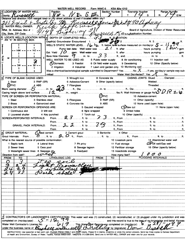
Specific Water Well Detail |
|
|
| Location Info | |||
| Owner: Jefferies, Keith | Status: Constructed | ||
| Location: T14S, R14W, Sec. 3, NW NE SE | County: Russell | ||
| Directions: 281 Exit and I-70, Russell: 0.13 mi W of 70 Hwy | |||
| Latitude: 38.862831 | Longitude: -98.8577226 | Datum NAD 27 | |
| Latitude: 38.8628425 | Longitude: -98.8580845 | Datum NAD 83 | |
| Longitude and latitude calculated by Survey from township-range-section-quarter calls. Only good to within the quarter call accuracy. | |||
| View well on interactive map | |||
| General Info | ||
| Well Depth: 33 ft. | Elevation: ft. | |
| Static Water Level: 16.5 ft. | Est. Yield: 10 gpm. | |
| Comp. Date: 12-May-1999 | Well Use: Domestic | |
| DWR Applic. #: | Other ID: | |
| Driller Info | ||
| Driller: Bushell Water Well Service | License #: 619 | |
| Scanned Form | View scan |
|
Chemical Sample Submitted?:
Water Well disinfected?: | ||
| Casing Info | ||
| Casing Type:
Casing Joints: |
Diam: in. to ft | |
| Casing height above land surface: in
Casing Weight: lbs/ft Wall thickness or gauge no.: | ||
| Screen and Perforation Info | ||
| Screen Type: | Screen Openings: | |
| Screen-perforated intervals | From: ft to ft | |
| Gravel pack intervals | From: ft to ft | |
| Grout Info | ||
| Grout used: | From: to ft | |
| Source of Possible Contamination | ||
| Source: | ||
| Direction from well: | Distance: ft | |
| Lithologic Log
(Log data entered by KGS.) | ||
| From: 0 ft. to 3 ft. | top soil | |
| From: 3 ft. to 24 ft. | light brown clay | |
| From: 24 ft. to 29 ft. | white clay | |
| From: 29 ft. to 33 ft. | dark shale | |