|
|
|
Specific Water Well Detail |
|
|
| Location Info | |||
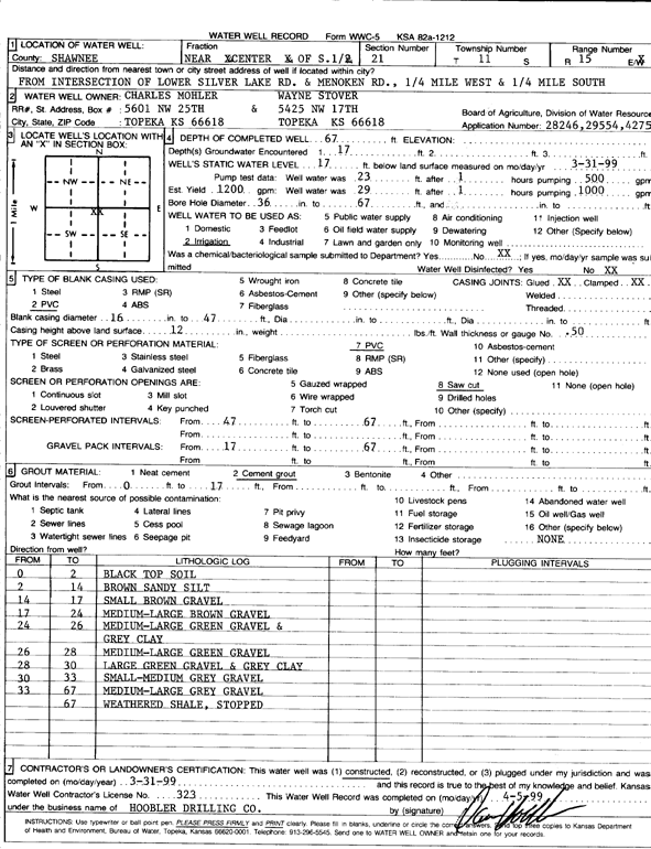
| Owner: Mohler, Charles and Wayne Stover | Status: Constructed | ||
| Location: T11S, R15E, Sec. 21, S2 | County: Shawnee | ||
| Directions: from Lower Silver Lake Rd and Menoken Rd: .25 mi W, .25 mi S | |||
| Latitude: 39.0764219 | Longitude: -95.7523021 | Datum NAD 27 | |
| Latitude: 39.0764218 | Longitude: -95.7525636 | Datum NAD 83 | |
| Longitude and latitude calculated by Survey from township-range-section-quarter calls. Only good to within the quarter call accuracy. | |||
| View well on interactive map | |||
| General Info | ||
| Well Depth: 67 ft. | Elevation: ft. | |
| Static Water Level: 17 ft. | Est. Yield: 1200 gpm. | |
| Comp. Date: 31-Mar-1999 | Well Use: Irrigation | |
| DWR Applic. #: 28246, 29554, 42750 | Other ID: | |
| Links | |
| No Wizard information available. | |
| View info from WIMAS Water Right Data base... | |
| Driller Info | ||
| Driller: Hoobler Drilling Company | License #: 323 | |
| Scanned Form | View scan |
|
Chemical Sample Submitted?:
Water Well disinfected?: | ||
| Casing Info | ||
| Casing Type:
Casing Joints: |
Diam: in. to ft | |
| Casing height above land surface: in
Casing Weight: lbs/ft Wall thickness or gauge no.: | ||
| Screen and Perforation Info | ||
| Screen Type: | Screen Openings: | |
| Screen-perforated intervals | From: ft to ft | |
| Gravel pack intervals | From: ft to ft | |
| Grout Info | ||
| Grout used: | From: to ft | |
| Source of Possible Contamination | ||
| Source: | ||
| Direction from well: | Distance: ft | |
| Lithologic Log
(Log data entered by KGS.) | ||
| From: 0 ft. to 2 ft. | black top soil | |
| From: 2 ft. to 14 ft. | brown sandy silt | |
| From: 14 ft. to 17 ft. | small brown gravel | |
| From: 17 ft. to 24 ft. | medium-large brown gravel | |
| From: 24 ft. to 26 ft. | medium-large green gravel and gray clay | |
| From: 26 ft. to 28 ft. | medium-large green gravel | |
| From: 28 ft. to 30 ft. | large green gravel and gray clay | |
| From: 30 ft. to 33 ft. | small-medium gray gravel | |
| From: 33 ft. to 67 ft. | medium-large gray gravel | |
| From: 67 ft. to ft. | weathered shale | |