|
|
|
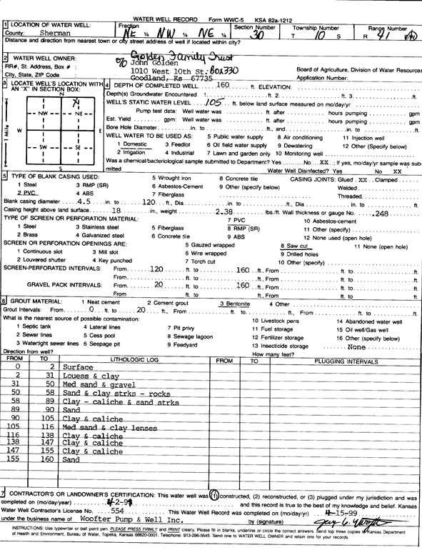
Specific Water Well Detail |
|
|
| Location Info | |||
| Owner: Golden Family Trust | Status: Constructed | ||
| Location: T10S, R41W, Sec. 30, NE NW NE | County: Sherman | ||
| Directions: | |||
| Latitude: 39.161336 | Longitude: -101.9372128 | Datum NAD 27 | |
| Latitude: 39.1613386 | Longitude: -101.937668 | Datum NAD 83 | |
| Longitude and latitude calculated by Survey from township-range-section-quarter calls. Only good to within the quarter call accuracy. | |||
| View well on interactive map | |||
| General Info | ||
| Well Depth: 160 ft. | Elevation: ft. | |
| Static Water Level: 105 ft. | Est. Yield: gpm. | |
| Comp. Date: 02-Apr-1999 | Well Use: Domestic | |
| DWR Applic. #: | Other ID: | |
| Driller Info | ||
| Driller: Woofter Pump & Well, Inc. | License #: 554 | |
| Scanned Form | View scan |
|
Chemical Sample Submitted?:
Water Well disinfected?: | ||
| Casing Info | ||
| Casing Type:
Casing Joints: |
Diam: in. to ft | |
| Casing height above land surface: in
Casing Weight: lbs/ft Wall thickness or gauge no.: | ||
| Screen and Perforation Info | ||
| Screen Type: | Screen Openings: | |
| Screen-perforated intervals | From: ft to ft | |
| Gravel pack intervals | From: ft to ft | |
| Grout Info | ||
| Grout used: | From: to ft | |
| Source of Possible Contamination | ||
| Source: | ||
| Direction from well: | Distance: ft | |
| Lithologic Log
(Log data entered by KGS.) | ||
| From: 0 ft. to 2 ft. | Surface | |
| From: 2 ft. to 31 ft. | Loess and clay | |
| From: 31 ft. to 50 ft. | Medium sand and gravel | |
| From: 50 ft. to 58 ft. | Sand and clay streaks, rocks | |
| From: 58 ft. to 89 ft. | Clay, caliche and sand streaks | |
| From: 89 ft. to 90 ft. | Sand | |
| From: 90 ft. to 105 ft. | Clay and caliche | |
| From: 105 ft. to 116 ft. | Medium sand and clay lenses | |
| From: 116 ft. to 138 ft. | Clay and caliche | |
| From: 138 ft. to 147 ft. | Clay and caliche | |
| From: 147 ft. to 155 ft. | Clay and caliche | |
| From: 155 ft. to 160 ft. | Sand | |