|
|
|
Specific Water Well Detail |
|
|
| Location Info | |||
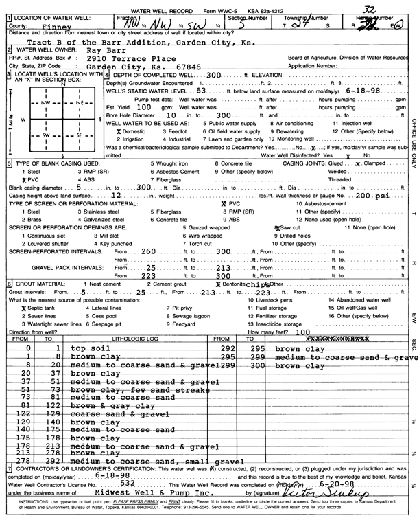
| Owner: Barr, Ray | Status: Constructed | ||
| Location: T24S, R32W, Sec. 5, NW NW SW | County: Finney | ||
| Directions: tract B of the Barr Addition, Garden City | |||
| Latitude: 37.9958147 | Longitude: -100.8640577 | Datum NAD 27 | |
| Latitude: 37.9958375 | Longitude: -100.8644967 | Datum NAD 83 | |
| Longitude and latitude calculated by Survey from township-range-section-quarter calls. Only good to within the quarter call accuracy. | |||
| View well on interactive map | |||
| General Info | ||
| Well Depth: 300 ft. | Elevation: ft. | |
| Static Water Level: 63 ft. | Est. Yield: 100 gpm. | |
| Comp. Date: 18-Jun-1998 | Well Use: Domestic | |
| DWR Applic. #: | Other ID: | |
| Driller Info | ||
| Driller: Midwest Well & Pump, Inc. | License #: 532 | |
| Scanned Form | View scan |
|
Chemical Sample Submitted?:
Water Well disinfected?: | ||
| Casing Info | ||
| Casing Type:
Casing Joints: |
Diam: in. to ft | |
| Casing height above land surface: in
Casing Weight: lbs/ft Wall thickness or gauge no.: | ||
| Screen and Perforation Info | ||
| Screen Type: | Screen Openings: | |
| Screen-perforated intervals | From: ft to ft | |
| Gravel pack intervals | From: ft to ft | |
| Grout Info | ||
| Grout used: | From: to ft | |
| Source of Possible Contamination | ||
| Source: | ||
| Direction from well: | Distance: ft | |
| Lithologic Log
(Log data entered by KGS.) | ||
| From: 0 ft. to 1 ft. | top soil | |
| From: 1 ft. to 8 ft. | brown clay | |
| From: 8 ft. to 20 ft. | medium to coarse sand and gravel | |
| From: 20 ft. to 37 ft. | brown clay | |
| From: 37 ft. to 51 ft. | medium to coarse sand and gravel | |
| From: 51 ft. to 73 ft. | brown clay, few sand streaks | |
| From: 73 ft. to 81 ft. | medium to coarse sand | |
| From: 81 ft. to 122 ft. | brown and gray clay | |
| From: 122 ft. to 129 ft. | coarse sand and gravel | |
| From: 129 ft. to 140 ft. | brown clay | |
| From: 140 ft. to 175 ft. | medium to coarse sand | |
| From: 175 ft. to 178 ft. | brown clay | |
| From: 178 ft. to 213 ft. | medium to coarse sand and gravel | |
| From: 213 ft. to 278 ft. | brown clay | |
| From: 278 ft. to 292 ft. | medium to coarse sand, small gravel | |
| From: 292 ft. to 295 ft. | brown clay | |
| From: 295 ft. to 299 ft. | medium to coarse sand and gravel | |
| From: 299 ft. to 300 ft. | brown clay | |