|
|
|
Specific Water Well Detail |
|
|
| Location Info | |||
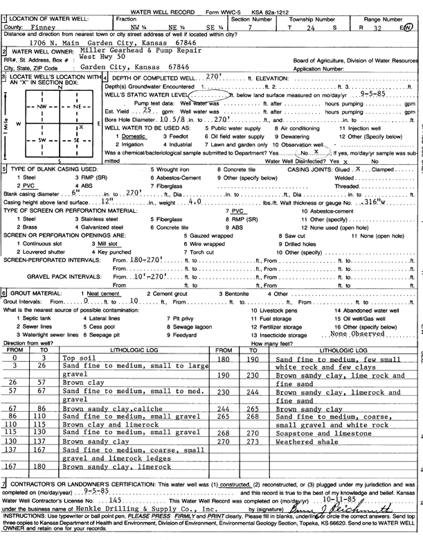
| Owner: Miller Gearhead and Pump Repair | Status: Constructed | ||
| Location: T24S, R32W, Sec. 7, NW NE SE | County: Finney | ||
| Directions: 1706 N Main, Garden City | |||
| Latitude: 37.9813898 | Longitude: -100.8684085 | Datum NAD 27 | |
| Latitude: 37.9814128 | Longitude: -100.8688479 | Datum NAD 83 | |
| Longitude and latitude calculated by Survey from township-range-section-quarter calls. Only good to within the quarter call accuracy. | |||
| View well on interactive map | |||
| General Info | ||
| Well Depth: 270 ft. | Elevation: ft. | |
| Static Water Level: ft. | Est. Yield: gpm. | |
| Comp. Date: 05-Sep-1985 | Well Use: Domestic | |
| DWR Applic. #: | Other ID: | |
| Driller Info | ||
| Driller: Hydro Resources Mid Continent, Inc. | License #: 145 | |
| Scanned Form | View scan |
|
Chemical Sample Submitted?:
Water Well disinfected?: | ||
| Casing Info | ||
| Casing Type:
Casing Joints: |
Diam: in. to ft | |
| Casing height above land surface: in
Casing Weight: lbs/ft Wall thickness or gauge no.: | ||
| Screen and Perforation Info | ||
| Screen Type: | Screen Openings: | |
| Screen-perforated intervals | From: ft to ft | |
| Gravel pack intervals | From: ft to ft | |
| Grout Info | ||
| Grout used: | From: to ft | |
| Source of Possible Contamination | ||
| Source: | ||
| Direction from well: | Distance: ft | |
| Lithologic Log
(Log data entered by KGS.) | ||
| From: 0 ft. to 3 ft. | top soil | |
| From: 3 ft. to 26 ft. | sand fine to medium, small to large gravel | |
| From: 26 ft. to 57 ft. | brown clay | |
| From: 57 ft. to 67 ft. | sand fine to medium, small to medium gravel | |
| From: 67 ft. to 86 ft. | brown sandy clay, caliche | |
| From: 86 ft. to 110 ft. | sand fine to medium, small gravel | |
| From: 110 ft. to 115 ft. | brown clay and limerock | |
| From: 115 ft. to 130 ft. | sand fine to medium, small gravel | |
| From: 130 ft. to 137 ft. | brown sandy clay | |
| From: 137 ft. to 167 ft. | sand fine to medium, coarse, small gravel and limerock ledges | |
| From: 167 ft. to 180 ft. | brown sandy clay, limerock | |
| From: 180 ft. to 190 ft. | sand fine to medium, few small white rock and few clays | |
| From: 190 ft. to 230 ft. | brown sandy clay, lime rock and fine sand | |
| From: 230 ft. to 244 ft. | brown sandy clay, limerock and fine sand | |
| From: 244 ft. to 265 ft. | brown sandy clay | |
| From: 265 ft. to 268 ft. | sand fine to medium, coarse, small gravel and white rock | |
| From: 268 ft. to 270 ft. | soapstone and limestone | |
| From: 270 ft. to 273 ft. | weathered shale | |