|
|
|
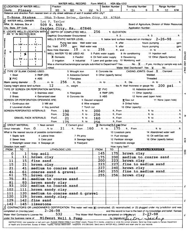
Specific Water Well Detail |
|
|
| Location Info | |||
| Owner: Taylor, Lot F. | Status: Constructed | ||
| Location: T24S, R32W, Sec. 10, NE NE SW | County: Finney | ||
| Directions: 1844 T-Bone Drive, Garden City | |||
| Latitude: 37.9811235 | Longitude: -100.8204033 | Datum NAD 27 | |
| Latitude: 37.9811461 | Longitude: -100.8208408 | Datum NAD 83 | |
| Longitude and latitude calculated by Survey from township-range-section-quarter calls. Only good to within the quarter call accuracy. | |||
| View well on interactive map | |||
| General Info | ||
| Well Depth: 256 ft. | Elevation: ft. | |
| Static Water Level: ft. | Est. Yield: 100 gpm. | |
| Comp. Date: 26-Feb-1998 | Well Use: Domestic | |
| DWR Applic. #: | Other ID: | |
| Driller Info | ||
| Driller: Midwest Well & Pump, Inc. | License #: 532 | |
| Scanned Form | View scan |
|
Chemical Sample Submitted?:
Water Well disinfected?: | ||
| Casing Info | ||
| Casing Type:
Casing Joints: |
Diam: in. to ft | |
| Casing height above land surface: in
Casing Weight: lbs/ft Wall thickness or gauge no.: | ||
| Screen and Perforation Info | ||
| Screen Type: | Screen Openings: | |
| Screen-perforated intervals | From: ft to ft | |
| Gravel pack intervals | From: ft to ft | |
| Grout Info | ||
| Grout used: | From: to ft | |
| Source of Possible Contamination | ||
| Source: | ||
| Direction from well: | Distance: ft | |
| Lithologic Log
(Log data entered by KGS.) | ||
| From: 0 ft. to 1 ft. | top soil | |
| From: 1 ft. to 11 ft. | brown clay | |
| From: 11 ft. to 15 ft. | fine sand | |
| From: 15 ft. to 21 ft. | brown clay | |
| From: 21 ft. to 41 ft. | medium to coarse sand | |
| From: 41 ft. to 61 ft. | coarse sand and gravel | |
| From: 61 ft. to 75 ft. | brown clay | |
| From: 75 ft. to 81 ft. | medium to coarse sand | |
| From: 81 ft. to 93 ft. | brown sandy clay | |
| From: 93 ft. to 102 ft. | medium to coarse sand | |
| From: 102 ft. to 111 ft. | brown sandy clay | |
| From: 111 ft. to 120 ft. | medium to coarse sand and gravel | |
| From: 120 ft. to 129 ft. | brown sandy clay | |
| From: 129 ft. to 142 ft. | fine sand | |
| From: 142 ft. to 145 ft. | limestone | |
| From: 145 ft. to 175 ft. | brown clay | |
| From: 175 ft. to 200 ft. | medium to coarse sand | |
| From: 200 ft. to 223 ft. | brown clay | |
| From: 223 ft. to 227 ft. | fine to medium sand | |
| From: 227 ft. to 240 ft. | brown clay | |
| From: 240 ft. to 255 ft. | fine to medium sand | |
| From: 255 ft. to 256 ft. | brown clay | |