|
|
|
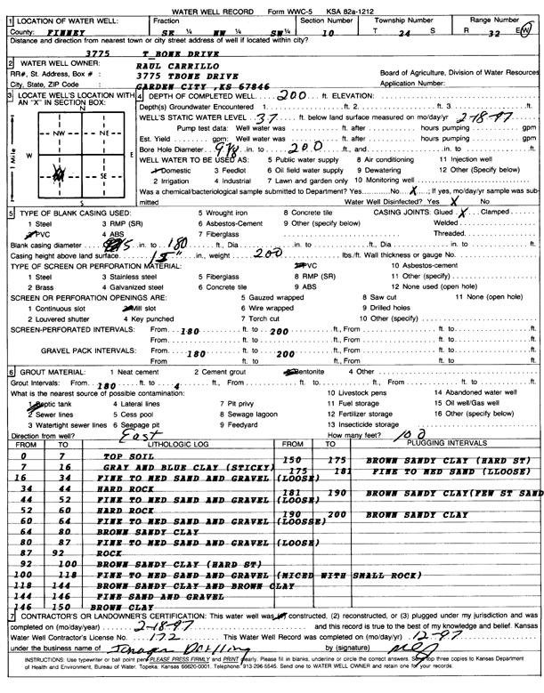
Specific Water Well Detail |
|
|
| Location Info | |||
| Owner: Carrillo, Raul | Status: Constructed | ||
| Location: T24S, R32W, Sec. 10, SE NW SW | County: Finney | ||
| Directions: 3775 T-Bone Drive, Garden City | |||
| Latitude: 37.9793372 | Longitude: -100.8249576 | Datum NAD 27 | |
| Latitude: 37.9793599 | Longitude: -100.8253953 | Datum NAD 83 | |
| Longitude and latitude calculated by Survey from township-range-section-quarter calls. Only good to within the quarter call accuracy. | |||
| View well on interactive map | |||
| General Info | ||
| Well Depth: 200 ft. | Elevation: ft. | |
| Static Water Level: 37 ft. | Est. Yield: gpm. | |
| Comp. Date: 18-Feb-1997 | Well Use: Domestic | |
| DWR Applic. #: | Other ID: | |
| Driller Info | ||
| Driller: Jonagan Water Well Service LLC | License #: 172 | |
| Scanned Form | View scan |
|
Chemical Sample Submitted?:
Water Well disinfected?: | ||
| Casing Info | ||
| Casing Type:
Casing Joints: |
Diam: in. to ft | |
| Casing height above land surface: in
Casing Weight: lbs/ft Wall thickness or gauge no.: | ||
| Screen and Perforation Info | ||
| Screen Type: | Screen Openings: | |
| Screen-perforated intervals | From: ft to ft | |
| Gravel pack intervals | From: ft to ft | |
| Grout Info | ||
| Grout used: | From: to ft | |
| Source of Possible Contamination | ||
| Source: | ||
| Direction from well: | Distance: ft | |
| Lithologic Log
(Log data entered by KGS.) | ||
| From: 0 ft. to 7 ft. | top soil | |
| From: 7 ft. to 16 ft. | gray and blue clay (sticky) | |
| From: 16 ft. to 34 ft. | fine to medium sand and gravel (loose) | |
| From: 34 ft. to 44 ft. | hard rock | |
| From: 44 ft. to 52 ft. | fine to medium sand and gravel (loose) | |
| From: 52 ft. to 60 ft. | hard rock | |
| From: 60 ft. to 64 ft. | fine to medium sand and gravel (loose) | |
| From: 64 ft. to 80 ft. | brown sandy clay | |
| From: 80 ft. to 87 ft. | fine to medium sand and gravel (loose) | |
| From: 87 ft. to 92 ft. | rock | |
| From: 92 ft. to 100 ft. | brown sandy clay (hard st) | |
| From: 100 ft. to 118 ft. | fine to medium sand and gravel (mixed with small rock) | |
| From: 118 ft. to 144 ft. | brown sandy clay and brown clay | |
| From: 144 ft. to 146 ft. | fine sand and gravel | |
| From: 146 ft. to 150 ft. | brown clay | |
| From: 150 ft. to 175 ft. | brown sandy clay (hard st) | |
| From: 175 ft. to 181 ft. | fine to medium sand (loose) | |
| From: 181 ft. to 190 ft. | brown sandy clay with few streaks of sand | |
| From: 190 ft. to 200 ft. | brown sandy clay | |