|
|
|
Specific Water Well Detail |
|
|
| Location Info | |||
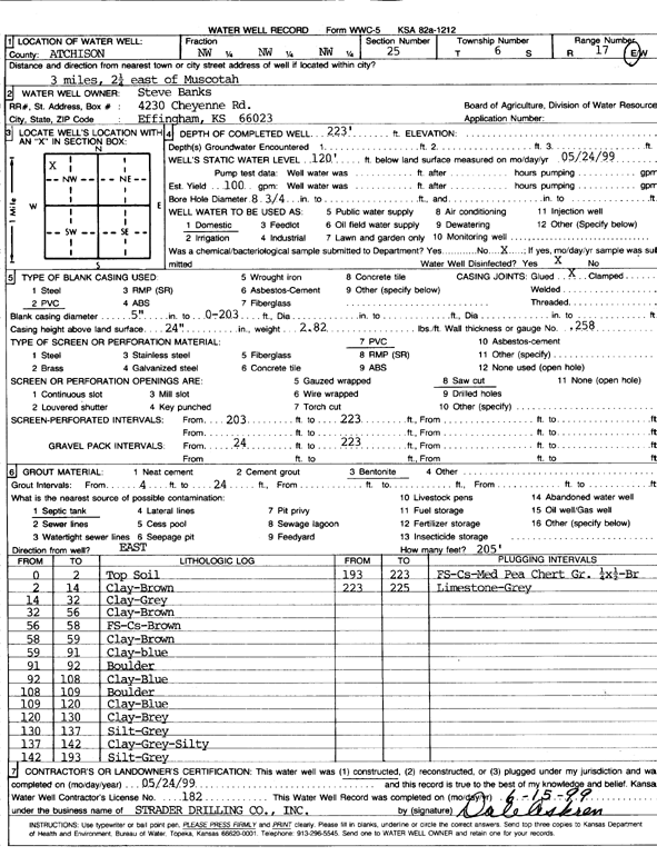
| Owner: Banks, Steve | Status: Constructed | ||
| Location: T6S, R17E, Sec. 25, NW NW NW | County: Atchison | ||
| Directions: from Muscotah: 3 mi, 2.25 mi E | |||
| Latitude: 39.5067917 | Longitude: -95.4768682 | Datum NAD 27 | |
| Latitude: 39.5067903 | Longitude: -95.4771227 | Datum NAD 83 | |
| Longitude and latitude calculated by Survey from township-range-section-quarter calls. Only good to within the quarter call accuracy. | |||
| View well on interactive map | |||
| General Info | ||
| Well Depth: 223 ft. | Elevation: ft. | |
| Static Water Level: 120 ft. | Est. Yield: 100 gpm. | |
| Comp. Date: 24-May-1999 | Well Use: Domestic | |
| DWR Applic. #: | Other ID: | |
| Driller Info | ||
| Driller: Strader Drilling Co., Inc. | License #: 182 | |
| Scanned Form | View scan |
|
Chemical Sample Submitted?:
Water Well disinfected?: | ||
| Casing Info | ||
| Casing Type:
Casing Joints: |
Diam: in. to ft | |
| Casing height above land surface: in
Casing Weight: lbs/ft Wall thickness or gauge no.: | ||
| Screen and Perforation Info | ||
| Screen Type: | Screen Openings: | |
| Screen-perforated intervals | From: ft to ft | |
| Gravel pack intervals | From: ft to ft | |
| Grout Info | ||
| Grout used: | From: to ft | |
| Source of Possible Contamination | ||
| Source: | ||
| Direction from well: | Distance: ft | |
| Lithologic Log
(Log data entered by KGS.) | ||
| From: 0 ft. to 2 ft. | Topsoil | |
| From: 2 ft. to 14 ft. | Clay, brown | |
| From: 14 ft. to 32 ft. | Clay, gray | |
| From: 32 ft. to 56 ft. | Clay, brown | |
| From: 56 ft. to 58 ft. | Fine sand, coarse sand, brown | |
| From: 58 ft. to 59 ft. | Clay, brown | |
| From: 59 ft. to 91 ft. | Clay, blue | |
| From: 91 ft. to 92 ft. | Boulder | |
| From: 92 ft. to 108 ft. | Clay, blue | |
| From: 108 ft. to 109 ft. | Boulder | |
| From: 109 ft. to 120 ft. | Clay, blue | |
| From: 120 ft. to 130 ft. | Clay, gray | |
| From: 130 ft. to 137 ft. | Silt, gray | |
| From: 137 ft. to 142 ft. | Clay, gray, silty | |
| From: 142 ft. to 193 ft. | Silt, gray | |
| From: 193 ft. to 223 ft. | Fine sand, coarse sand, medium pea chert gravel 1/4 x 1/2, brown | |
| From: 223 ft. to 225 ft. | Limestone, gray | |