|
|
|
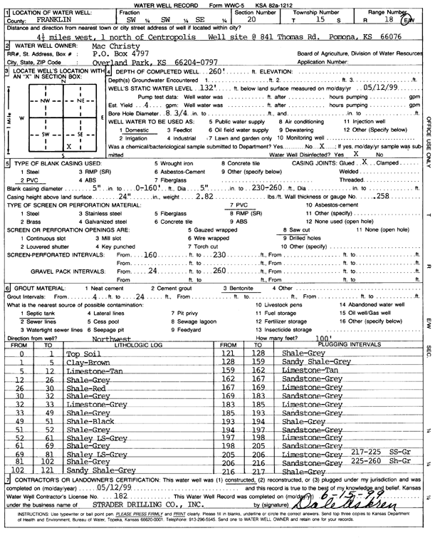
Specific Water Well Detail |
|
|
| Location Info | |||
| Owner: Christy, Mac | Status: Constructed | ||
| Location: T15S, R18E, Sec. 20, SW SW SE | County: Franklin | ||
| Directions: from Centropolis, 4.5 mi W and 1 mi N; 841 Thomas Rd, Pomona | |||
| Latitude: 38.7251409 | Longitude: -95.4349038 | Datum NAD 27 | |
| Latitude: 38.7251478 | Longitude: -95.4351596 | Datum NAD 83 | |
| Longitude and latitude calculated by Survey from township-range-section-quarter calls. Only good to within the quarter call accuracy. | |||
| View well on interactive map | |||
| General Info | ||
| Well Depth: 260 ft. | Elevation: ft. | |
| Static Water Level: 132 ft. | Est. Yield: 4 gpm. | |
| Comp. Date: 12-May-1999 | Well Use: Domestic | |
| DWR Applic. #: | Other ID: | |
| Driller Info | ||
| Driller: Strader Drilling Co., Inc. | License #: 182 | |
| Scanned Form | View scan |
|
Chemical Sample Submitted?:
Water Well disinfected?: | ||
| Casing Info | ||
| Casing Type:
Casing Joints: |
Diam: in. to ft | |
| Casing height above land surface: in
Casing Weight: lbs/ft Wall thickness or gauge no.: | ||
| Screen and Perforation Info | ||
| Screen Type: | Screen Openings: | |
| Screen-perforated intervals | From: ft to ft | |
| Gravel pack intervals | From: ft to ft | |
| Grout Info | ||
| Grout used: | From: to ft | |
| Source of Possible Contamination | ||
| Source: | ||
| Direction from well: | Distance: ft | |
| Lithologic Log
(Log data entered by KGS.) | ||
| From: 0 ft. to 1 ft. | Topsoil | |
| From: 1 ft. to 5 ft. | Clay, brown | |
| From: 5 ft. to 12 ft. | Limestone, tan | |
| From: 12 ft. to 26 ft. | Shale, gray | |
| From: 26 ft. to 30 ft. | Shale, red | |
| From: 30 ft. to 32 ft. | Shale, gray | |
| From: 32 ft. to 33 ft. | Limestone, gray | |
| From: 33 ft. to 49 ft. | Shale, gray | |
| From: 49 ft. to 51 ft. | Shale, black | |
| From: 51 ft. to 52 ft. | Shale, gray | |
| From: 52 ft. to 61 ft. | Shaley limestone, gray | |
| From: 61 ft. to 69 ft. | Shale, gray | |
| From: 69 ft. to 81 ft. | Shaley limestone, gray | |
| From: 81 ft. to 102 ft. | Shale, gray | |
| From: 102 ft. to 121 ft. | Sandy shale, gray | |
| From: 121 ft. to 128 ft. | Shale, gray | |
| From: 128 ft. to 159 ft. | Sandy shale, gray | |
| From: 159 ft. to 162 ft. | Limestone, tan | |
| From: 162 ft. to 167 ft. | Sandstone, gray | |
| From: 167 ft. to 169 ft. | Limestone, gray | |
| From: 169 ft. to 183 ft. | Sandstone, gray | |
| From: 183 ft. to 185 ft. | Limestone, gray | |
| From: 185 ft. to 193 ft. | Sandstone, gray | |
| From: 193 ft. to 194 ft. | Shale, gray | |
| From: 194 ft. to 197 ft. | Sandstone, gray | |
| From: 197 ft. to 198 ft. | Limestone, gray | |
| From: 198 ft. to 205 ft. | Sandstone, gray | |
| From: 205 ft. to 206 ft. | Limestone, gray | |
| From: 206 ft. to 216 ft. | Sandstone, gray | |
| From: 216 ft. to 217 ft. | Shale, gray | |
| From: 217 ft. to 225 ft. | Sandstone, gray | |
| From: 225 ft. to 260 ft. | Shale, gray | |