|
|
|
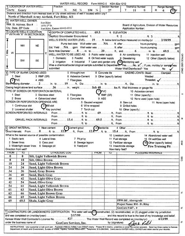
Specific Water Well Detail |
|
|
| Location Info | |||
| Owner: Fort Riley | Status: Constructed | ||
| Location: T11S, R6E, Sec. 27, NE SW | County: Geary | ||
| Directions: NE of Marshall Army Airfield, Ft. Riley | |||
| Latitude: 39.0641448 | Longitude: -96.7546343 | Datum NAD 27 | |
| Latitude: 39.0641427 | Longitude: -96.7549192 | Datum NAD 83 | |
| Longitude and latitude calculated by Survey from township-range-section-quarter calls. Only good to within the quarter call accuracy. | |||
| View well on interactive map | |||
| General Info | ||
| Well Depth: 69.5 ft. | Elevation: ft. | |
| Static Water Level: 19 ft. | Est. Yield: gpm. | |
| Comp. Date: 17-Feb-1999 | Well Use: Monitoring well/observation/piezometer | |
| DWR Applic. #: | Other ID: FP 99-36 I | |
| Driller Info | ||
| Driller: GeoCore Services Inc. | License #: 527 | |
| Scanned Form | View scan |
|
Chemical Sample Submitted?:
Water Well disinfected?: | ||
| Casing Info | ||
| Casing Type:
Casing Joints: |
Diam: in. to ft | |
| Casing height above land surface: in
Casing Weight: lbs/ft Wall thickness or gauge no.: | ||
| Screen and Perforation Info | ||
| Screen Type: | Screen Openings: | |
| Screen-perforated intervals | From: ft to ft | |
| Gravel pack intervals | From: ft to ft | |
| Grout Info | ||
| Grout used: | From: to ft | |
| Source of Possible Contamination | ||
| Source: | ||
| Direction from well: | Distance: ft | |
| Lithologic Log
(Log data entered by KGS.) | ||
| From: 0 ft. to 8 ft. | silt, light yellowish brown | |
| From: 8 ft. to 18 ft. | silt, olive brown | |
| From: 18 ft. to 24 ft. | sand, light yellowish brown | |
| From: 24 ft. to 34 ft. | sand, light olive brown | |
| From: 34 ft. to 36 ft. | sand, gray brown | |
| From: 36 ft. to 40 ft. | sand, dark gray | |
| From: 40 ft. to 42 ft. | sand, light olive gray | |
| From: 42 ft. to 54 ft. | sand, olive gray | |
| From: 54 ft. to 61 ft. | sand, light yellowish brown | |
| From: 61 ft. to 63 ft. | sand, light olive brown | |
| From: 63 ft. to 66 ft. | sand, light brown gray | |
| From: 66 ft. to 69 ft. | sand, light yellow brown | |
| From: 69 ft. to 69.5 ft. | shale, light gray | |