|
|
|
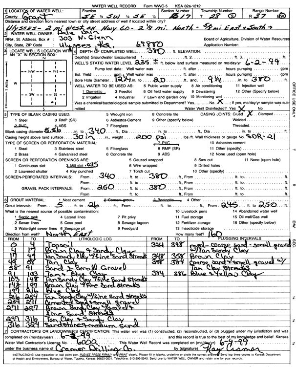
Specific Water Well Detail |
|
|
| Location Info | |||
| Owner: Bain, Dale | Status: Constructed | ||
| Location: T28S, R37W, Sec. 17, SE SW SE | County: Grant | ||
| Directions: from Ulysses: 2 mi W on Hwy 60, 2.13 mi N, .63 mi E, S into site | |||
| Latitude: 37.6064523 | Longitude: -101.3868678 | Datum NAD 27 | |
| Latitude: 37.606472 | Longitude: -101.3873155 | Datum NAD 83 | |
| Longitude and latitude calculated by Survey from township-range-section-quarter calls. Only good to within the quarter call accuracy. | |||
| View well on interactive map | |||
| General Info | ||
| Well Depth: 380 ft. | Elevation: ft. | |
| Static Water Level: 235 ft. | Est. Yield: gpm. | |
| Comp. Date: 02-Jun-1999 | Well Use: Domestic | |
| DWR Applic. #: | Other ID: | |
| Driller Info | ||
| Driller: Cramer Drilling Company | License #: 600 | |
| Scanned Form | View scan |
|
Chemical Sample Submitted?:
Water Well disinfected?: | ||
| Casing Info | ||
| Casing Type:
Casing Joints: |
Diam: in. to ft | |
| Casing height above land surface: in
Casing Weight: lbs/ft Wall thickness or gauge no.: | ||
| Screen and Perforation Info | ||
| Screen Type: | Screen Openings: | |
| Screen-perforated intervals | From: ft to ft | |
| Gravel pack intervals | From: ft to ft | |
| Grout Info | ||
| Grout used: | From: to ft | |
| Source of Possible Contamination | ||
| Source: | ||
| Direction from well: | Distance: ft | |
| Lithologic Log
(Log data entered by KGS.) | ||
| From: 0 ft. to 4 ft. | top soil | |
| From: 4 ft. to 17 ft. | brown clay and sandy clay | |
| From: 17 ft. to 49 ft. | tan sandy clay with fine sand streaks | |
| From: 49 ft. to 58 ft. | tan clay | |
| From: 58 ft. to 91 ft. | sand and small gravel | |
| From: 91 ft. to 103 ft. | tan and blue clay | |
| From: 103 ft. to 148 ft. | tan sandy clay with fine sand streaks | |
| From: 148 ft. to 197 ft. | brown clay with fine sand streaks | |
| From: 197 ft. to 216 ft. | blue clay | |
| From: 216 ft. to 254 ft. | tan sandy clay with fine sand streaks | |
| From: 254 ft. to 271 ft. | cemented sand and small gravel | |
| From: 271 ft. to 297 ft. | brown sandy clay with gravel and fine sand streaks | |
| From: 297 ft. to 316 ft. | tan clay and sandy clay | |
| From: 316 ft. to 324 ft. | sandstone and medium sand | |
| From: 324 ft. to 348 ft. | medium-coarse sand and small gravel with tan sandy clay | |
| From: 348 ft. to 358 ft. | brown clay | |
| From: 358 ft. to 384 ft. | coarse sand and small gravel with tan clay streaks | |
| From: 384 ft. to 386 ft. | blue and yellow clay | |