|
|
|
Specific Water Well Detail |
|
|
| Location Info | |||
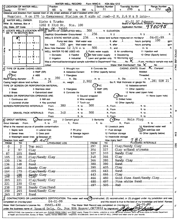
| Owner: Zinke and Trumbo | Status: Constructed | ||
| Location: T29S, R37W, Sec. 31, NE NW NW | County: Grant | ||
| Directions: from Hugoton: N on 270 to Compressor Station on E side of rd., 2 mi N, 2.6 mi W, S into site | |||
| Latitude: 37.4886865 | Longitude: -101.4129546 | Datum NAD 27 | |
| Latitude: 37.4887083 | Longitude: -101.4134001 | Datum NAD 83 | |
| Longitude and latitude calculated by Survey from township-range-section-quarter calls. Only good to within the quarter call accuracy. | |||
| View well on interactive map | |||
| General Info | ||
| Well Depth: 500 ft. | Elevation: ft. | |
| Static Water Level: 256 ft. | Est. Yield: 100 gpm. | |
| Comp. Date: 01-Apr-1999 | Well Use: Oil Field Water Supply | |
| DWR Applic. #: 990095 | Other ID: 1-31 DF Johnson | |
| Links | |
| No Wizard information available. | |
| View info from WIMAS Water Right Data base... | |
| Driller Info | ||
| Driller: Howard Drilling Company AG, LLC | License #: 430 | |
| Scanned Form | View scan |
|
Chemical Sample Submitted?:
Water Well disinfected?: | ||
| Casing Info | ||
| Casing Type:
Casing Joints: |
Diam: in. to ft | |
| Casing height above land surface: in
Casing Weight: lbs/ft Wall thickness or gauge no.: | ||
| Screen and Perforation Info | ||
| Screen Type: | Screen Openings: | |
| Screen-perforated intervals | From: ft to ft | |
| Gravel pack intervals | From: ft to ft | |
| Grout Info | ||
| Grout used: | From: to ft | |
| Source of Possible Contamination | ||
| Source: | ||
| Direction from well: | Distance: ft | |
| Lithologic Log
(Log data entered by KGS.) | ||
| From: 0 ft. to 2 ft. | Top soil | |
| From: 2 ft. to 87 ft. | Clay | |
| From: 87 ft. to 105 ft. | Sand | |
| From: 105 ft. to 120 ft. | Clay/Sandy Clay | |
| From: 120 ft. to 136 ft. | Clay | |
| From: 136 ft. to 148 ft. | Sand | |
| From: 148 ft. to 164 ft. | Sandy Clay | |
| From: 164 ft. to 175 ft. | Clay/Sandy Clay | |
| From: 175 ft. to 198 ft. | Sandy Clay | |
| From: 198 ft. to 205 ft. | Clay | |
| From: 205 ft. to 221 ft. | Clay/Sandy Clay | |
| From: 221 ft. to 238 ft. | Clay | |
| From: 238 ft. to 250 ft. | Sandy Clay/Sand | |
| From: 250 ft. to 265 ft. | Sand/Sandy Clay | |
| From: 265 ft. to 297 ft. | Sand | |
| From: 297 ft. to 304 ft. | Clay/Sandy Clay | |
| From: 304 ft. to 327 ft. | Clay with Sand Streaks | |
| From: 327 ft. to 340 ft. | Sandy Clay | |
| From: 340 ft. to 366 ft. | Clay | |
| From: 366 ft. to 380 ft. | Sandy Clay | |
| From: 380 ft. to 390 ft. | Sand | |
| From: 390 ft. to 405 ft. | Clay | |
| From: 405 ft. to 443 ft. | Sand | |
| From: 443 ft. to 466 ft. | Clay | |
| From: 466 ft. to 480 ft. | Gold fine Sand/Sandy Clay | |
| From: 480 ft. to 497 ft. | Fine white Sand | |
| From: 497 ft. to 505 ft. | Red | |