|
|
|
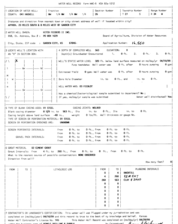
Specific Water Well Detail |
|
|
| Location Info | |||
| Owner: Hitch Feeders II | Status: Plugged | ||
| Location: T27S, R34W, Sec. 26, NW NW NW | County: Haskell | ||
| Directions: from Garden City: 20 mi S, 8 mi W | |||
| Latitude: 37.677438 | Longitude: -101.0152237 | Datum NAD 27 | |
| Latitude: 37.6774618 | Longitude: -101.0156704 | Datum NAD 83 | |
| Longitude and latitude calculated by Survey from township-range-section-quarter calls. Only good to within the quarter call accuracy. | |||
| View well on interactive map | |||
| General Info | ||
| Well Depth: 563 ft. | Elevation: ft. | |
| Static Water Level: 320 ft. | Est. Yield: gpm. | |
| Comp. Date: 10-Apr-1999 | Well Use: Feedlot | |
| DWR Applic. #: 16550 | Other ID: | |
| Driller Info | ||
| Driller: Henkle Drilling & Supply | License #: 145 | |
| Scanned Form | View scan |
| Casing Info | ||
|
Casing Type:
Diam: in. Casing height above land surface: in | ||
| Grout Info | ||
| Grout used: | From: to ft | |
| Source of Possible Contamination | ||
| Source: | ||
| Direction from well: | Distance: ft | |