|
|
|
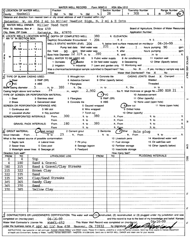
Specific Water Well Detail |
|
|
| Location Info | |||
| Owner: Miller Feed Yard | Status: Constructed | ||
| Location: T30S, R34W, Sec. 28, SW NW NW | County: Haskell | ||
| Directions: from Satanta: 2 mi W on 56 to Miller Feedlot sign, 2 mi N, E into site | |||
| Latitude: 37.4141341 | Longitude: -101.0514039 | Datum NAD 27 | |
| Latitude: 37.4141585 | Longitude: -101.0518484 | Datum NAD 83 | |
| Longitude and latitude calculated by Survey from township-range-section-quarter calls. Only good to within the quarter call accuracy. | |||
| View well on interactive map | |||
| General Info | ||
| Well Depth: 380 ft. | Elevation: ft. | |
| Static Water Level: 204 ft. | Est. Yield: 90 gpm. | |
| Comp. Date: 16-Apr-1999 | Well Use: Feedlot | |
| DWR Applic. #: | Other ID: | |
| Driller Info | ||
| Driller: HDC AG LLC | License #: 652 | |
| Scanned Form | View scan |
|
Chemical Sample Submitted?:
Water Well disinfected?: | ||
| Casing Info | ||
| Casing Type:
Casing Joints: |
Diam: in. to ft | |
| Casing height above land surface: in
Casing Weight: lbs/ft Wall thickness or gauge no.: | ||
| Screen and Perforation Info | ||
| Screen Type: | Screen Openings: | |
| Screen-perforated intervals | From: ft to ft | |
| Gravel pack intervals | From: ft to ft | |
| Grout Info | ||
| Grout used: | From: to ft | |
| Source of Possible Contamination | ||
| Source: | ||
| Direction from well: | Distance: ft | |
| Lithologic Log
(Log data entered by KGS.) | ||
| From: 0 ft. to 4 ft. | top | |
| From: 4 ft. to 180 ft. | sand and gravel | |
| From: 180 ft. to 315 ft. | sand and gravel/clay streaks | |
| From: 315 ft. to 322 ft. | brown clay | |
| From: 322 ft. to 335 ft. | sand | |
| From: 335 ft. to 345 ft. | clay/sand streaks | |
| From: 345 ft. to 365 ft. | sandy clay | |
| From: 365 ft. to 370 ft. | sand | |
| From: 370 ft. to 385 ft. | yellow clay | |