|
|
|
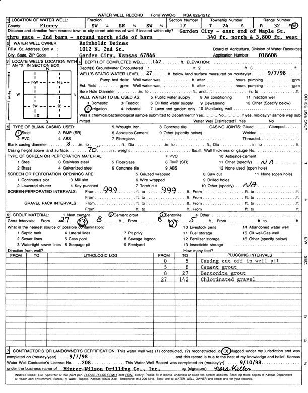
Specific Water Well Detail |
|
|
| Location Info | |||
| Owner: Deines, Reinholdt | Status: Plugged | ||
| Location: T24S, R32W, Sec. 17, SW SE SW | County: Finney | ||
| Directions: E end of Maple St, thru gate, around N side of 2nd barn, 340 feet N and 3800 feet W | |||
| Latitude: 37.9613943 | Longitude: -100.8592417 | Datum NAD 27 | |
| Latitude: 37.9614174 | Longitude: -100.8596809 | Datum NAD 83 | |
| Longitude and latitude calculated by Survey from township-range-section-quarter calls. Only good to within the quarter call accuracy. | |||
| View well on interactive map | |||
| General Info | ||
| Well Depth: 142 ft. | Elevation: ft. | |
| Static Water Level: 27 ft. | Est. Yield: gpm. | |
| Comp. Date: 07-Sep-1998 | Well Use: Irrigation | |
| DWR Applic. #: 18608 | Other ID: | |
| Links | |
| No Wizard information available. | |
| View info from WIMAS Water Right Data base... | |
| Driller Info | ||
| Driller: Minter-Wilson Drlg. Co., Inc. | License #: 208 | |
| Scanned Form | View scan |
| Casing Info | ||
|
Casing Type:
Diam: in. Casing height above land surface: in | ||
| Grout Info | ||
| Grout used: | From: to ft | |
| Source of Possible Contamination | ||
| Source: | ||
| Direction from well: | Distance: ft | |