|
|
|
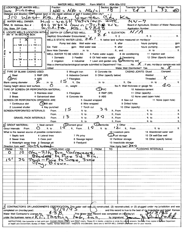
Specific Water Well Detail |
|
|
| Location Info | |||
| Owner: Mid-West Petroleum Co. | Status: Constructed | ||
| Location: T24S, R32W, Sec. 18, NE NE NW | County: Finney | ||
| Directions: 310 W Kansas Ave | |||
| Latitude: 37.9741061 | Longitude: -100.8751203 | Datum NAD 27 | |
| Latitude: 37.9741292 | Longitude: -100.8755601 | Datum NAD 83 | |
| Longitude and latitude calculated by Survey from township-range-section-quarter calls. Only good to within the quarter call accuracy. | |||
| View well on interactive map | |||
| General Info | ||
| Well Depth: 30 ft. | Elevation: ft. | |
| Static Water Level: 24.1 ft. | Est. Yield: gpm. | |
| Comp. Date: 10-Mar-1995 | Well Use: Monitoring well/observation/piezometer | |
| DWR Applic. #: | Other ID: MW 7 | |
| Driller Info | ||
| Driller: K.C. Testing Lab, Inc. | License #: 438 | |
| Scanned Form | View scan |
|
Chemical Sample Submitted?:
Water Well disinfected?: | ||
| Casing Info | ||
| Casing Type:
Casing Joints: |
Diam: in. to ft | |
| Casing height above land surface: in
Casing Weight: lbs/ft Wall thickness or gauge no.: | ||
| Screen and Perforation Info | ||
| Screen Type: | Screen Openings: | |
| Screen-perforated intervals | From: ft to ft | |
| Gravel pack intervals | From: ft to ft | |
| Grout Info | ||
| Grout used: | From: to ft | |
| Source of Possible Contamination | ||
| Source: | ||
| Direction from well: | Distance: ft | |
| Lithologic Log
(Log data entered by KGS.) | ||
| From: 0 ft. to 10 ft. | silty clay, brown, calcareous, grades to fine sand, brown | |
| From: 10 ft. to 30 ft. | fine to coarse sand, some clay, brown | |