|
|
|
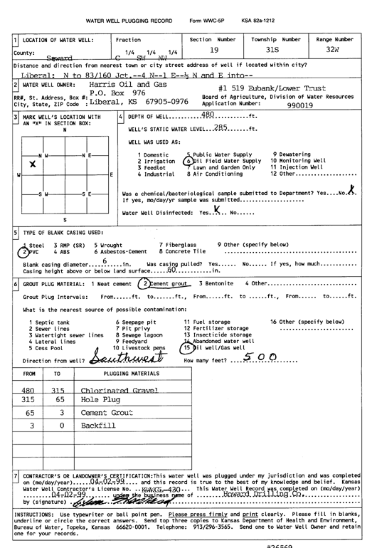
Specific Water Well Detail |
|
|
| Location Info | |||
| Owner: Harris Oil and Gas | Status: Plugged | ||
| Location: T31S, R32W, Sec. 19, C SW NW | County: Seward | ||
| Directions: from Liberal: N to hwy 83 and 160 Jct., 4 mi N, 1 mi E, .5 mi N, E into | |||
| Latitude: 37.3388601 | Longitude: -100.8482476 | Datum NAD 27 | |
| Latitude: 37.3388828 | Longitude: -100.8486863 | Datum NAD 83 | |
| Longitude and latitude calculated by Survey from township-range-section-quarter calls. Only good to within the quarter call accuracy. | |||
| View well on interactive map | |||
| General Info | ||
| Well Depth: 480 ft. | Elevation: ft. | |
| Static Water Level: 285 ft. | Est. Yield: gpm. | |
| Comp. Date: 02-Apr-1999 | Well Use: Oil Field Water Supply | |
| DWR Applic. #: 990019 | Other ID: Eubank Lower Trust 1-519 | |
| Links | |
| No Wizard information available. | |
| View info from WIMAS Water Right Data base... | |
| Driller Info | ||
| Driller: Howard Drilling Company AG, LLC | License #: 430 | |
| Scanned Form | View scan |
| Casing Info | ||
|
Casing Type:
Diam: in. Casing height above land surface: in | ||
| Grout Info | ||
| Grout used: | From: to ft | |
| Source of Possible Contamination | ||
| Source: | ||
| Direction from well: | Distance: ft | |