|
|
|
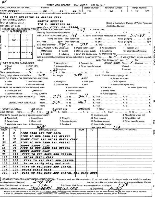
Specific Water Well Detail |
|
|
| Location Info | |||
| Owner: Hessler, Huston | Status: Constructed | ||
| Location: T24S, R32W, Sec. 19, SE SE NW | County: Finney | ||
| Directions: 510 E Burnside Dr, Garden City | |||
| Latitude: 37.9541376 | Longitude: -100.875058 | Datum NAD 27 | |
| Latitude: 37.9541608 | Longitude: -100.8754979 | Datum NAD 83 | |
| Longitude and latitude calculated by Survey from township-range-section-quarter calls. Only good to within the quarter call accuracy. | |||
| View well on interactive map | |||
| General Info | ||
| Well Depth: 267 ft. | Elevation: ft. | |
| Static Water Level: 48 ft. | Est. Yield: gpm. | |
| Comp. Date: 10-Feb-1989 | Well Use: Domestic | |
| DWR Applic. #: | Other ID: | |
| Driller Info | ||
| Driller: Jonagan Water Well Service LLC | License #: 172 | |
| Scanned Form | View scan |
|
Chemical Sample Submitted?:
Water Well disinfected?: | ||
| Casing Info | ||
| Casing Type:
Casing Joints: |
Diam: in. to ft | |
| Casing height above land surface: in
Casing Weight: lbs/ft Wall thickness or gauge no.: | ||
| Screen and Perforation Info | ||
| Screen Type: | Screen Openings: | |
| Screen-perforated intervals | From: ft to ft | |
| Gravel pack intervals | From: ft to ft | |
| Grout Info | ||
| Grout used: | From: to ft | |
| Source of Possible Contamination | ||
| Source: | ||
| Direction from well: | Distance: ft | |
| Lithologic Log
(Log data entered by KGS.) | ||
| From: 0 ft. to 2 ft. | fine sand and top soil | |
| From: 2 ft. to 5 ft. | fine to medium sand and gravel | |
| From: 5 ft. to 55 ft. | brown clay and brown sandy clay | |
| From: 55 ft. to 61 ft. | fine to medium sand and gravel | |
| From: 61 ft. to 65 ft. | brown sandy clay | |
| From: 65 ft. to 76 ft. | fine to medium sand and gravel | |
| From: 76 ft. to 95 ft. | brown sandy clay | |
| From: 95 ft. to 113 ft. | fine to medium sand and gravel | |
| From: 113 ft. to 120 ft. | brown sandy clay | |
| From: 120 ft. to 136 ft. | fine to medium sand and gravel | |
| From: 136 ft. to 160 ft. | brown sandy clay and rock | |
| From: 160 ft. to 173 ft. | fine to medium sand and gravel | |
| From: 173 ft. to 200 ft. | brown sandy clay | |
| From: 200 ft. to 267 ft. | fine to medium sand and gravel and hard rock | |